Touba geodata
Touba (Woroba) is a seat of a second-order administrative division; located in Ivory Coast in Africa/Abidjan (GMT+0) time zone. With population of 27,504 people, there are 45 cities with bigger population in this country. Compared to other cities in Ivory Coast, 78.6% of cities are located further ↓South; 92.3% of cities are located further →East and 96.6% of cities have lower elevation than Touba. Note1


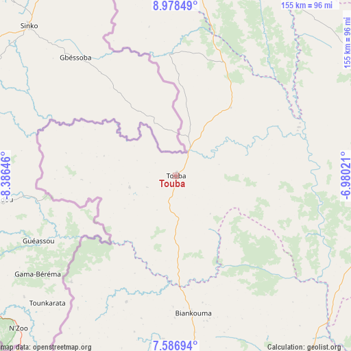
Touba GPS coordinates[2]
8° 16' 59.988" North, 7° 40' 59.988" West
| Map corner | latitude | longitude |
|---|---|---|
| Upper-left | 8.97849°, | -8.38646° |
| Center: | 8.28333°, | -7.68333° |
| Lower-right: | 7.58694°, | -6.98021° |
| Map W x H: | 154.7×154.7 km | = 96.1×96.1mi |
| max Lat: | 10.48115° ⇑21.4% North |
| Touba: | 8.28333° |
| min Lat: | ⇓78.6% South 4.42295° |
| min Long | Touba | max Long |
| -8.42592° | -7.68333° | -2.80003° |
| W 7.7%⇐ | ⇒92.3% E |
Elevation
Elevation of Touba is 470 m = 1542 ft, and this is 245.7 m = 806 ft above average elevation for this country.
| Max E: |
556 m = 1824 ft | 3.4% |
| Touba | 470 m 1542 ft | |
| Avg. | 224.3 m = 736 ft | |
Min E: |
7 m = 23 ft | 96.6% |
See also: Ivory Coast elevation on elevation.city.
Geographical zone
Touba is located in North Torrid zone (between Equator and Tropic of Cancer). Distance of Equator is 921 km =572.3 mi to South.| Distance of | km | miles | from Touba |
|---|---|---|---|
| North Pole | 9086 | 5645.8 | to North |
| Arctic Circle | 6480.2 | 4026.6 | to North |
| Tropic Cancer | 1684.9 | 1046.9 | to North |
| Equator | 921 | 572.3 | to South |


Nearby cities:
15 places around Touba: (largest is in red/bold)
• Bangolo
143 km =88.9 mi,  171°
171°
• Biankouma
61 km =37.9 mi, 172°
• Danané
125.1 km =77.7 mi,  204°
204°
• Facobly
105.1 km =65.3 mi,  161°
161°
• Gbéléban
152.8 km =94.9 mi,  341°
341°
• Kani
120.6 km =74.9 mi,  79°
79°
• Koro
38.7 km =24 mi,  38°
38°
• Kouibly
124.4 km =77.3 mi, 156°
• Man
97.9 km =60.8 mi, 171°
• Odienné
136.5 km =84.8 mi,  5°
5°
• Ouaninou
20.8 km =12.9 mi,  255°
255°
• Sipilou
65.5 km =40.7 mi,  224°
224°
• Séguéla
116.8 km =72.6 mi,  107°
107°
• Séguélon
134.4 km =83.5 mi,  27°
27°
• Zouan-Hounien
162.2 km =100.8 mi, 200°
Sources, notices
• [Note1] Compared only with cities in Ivory Coast existing in our database
• [Src1] Map data: © OpenStreetMap contributors (CC-BY-SA)
• [Src2] Other city data from geonames.org with taken over terms of usage.
• [Src3] Geographical zone / Annual Mean Temperature by Robert A. Rohde @ Wikipedia
