Danané geodata
Danané (Montagnes) is a seat of a third-order administrative division; located in Ivory Coast in Africa/Abidjan (GMT+0) time zone. With population of 53,808 people, there are 22 cities with bigger population in this country. Compared to other cities in Ivory Coast, 58.1% of cities are located further ↓South; 97.4% of cities are located further →East and 79.5% of cities have lower elevation than Danané. Note1


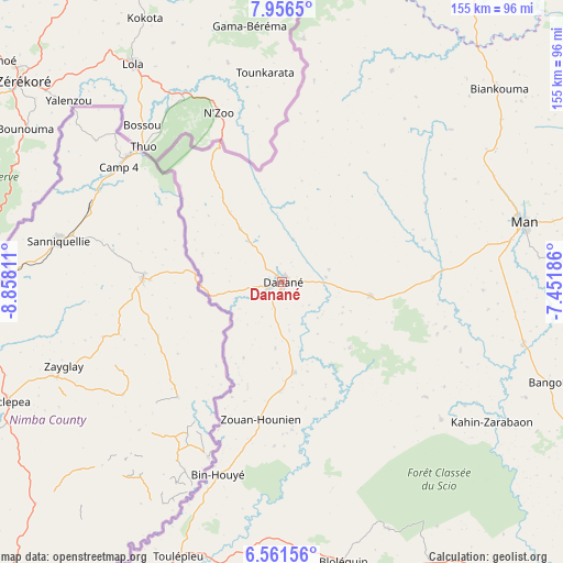
Danané GPS coordinates[2]
7° 15' 34.452" North, 8° 9' 17.928" West
| Map corner | latitude | longitude |
|---|---|---|
| Upper-left | 7.9565°, | -8.85811° |
| Center: | 7.25957°, | -8.15498° |
| Lower-right: | 6.56156°, | -7.45186° |
| Map W x H: | 155.1×155.1 km | = 96.4×96.4mi |
| max Lat: | 10.48115° ⇑41.9% North |
| Danané: | 7.25957° |
| min Lat: | ⇓58.1% South 4.42295° |
| min Long | Danané | max Long |
| -8.42592° | -8.15498° | -2.80003° |
| W 2.6%⇐ | ⇒97.4% E |
Elevation
Elevation of Danané is 347 m = 1138 ft, and this is 122.7 m = 403 ft above average elevation for this country.
| Max E: |
556 m = 1824 ft | 20.5% |
| Danané | 347 m 1138 ft | |
| Avg. | 224.3 m = 736 ft | |
Min E: |
7 m = 23 ft | 79.5% |
See also: Danané elevation on elevation.city.
Geographical zone
Danané is located in North Torrid zone (between Equator and Tropic of Cancer). Distance of Equator is 807.2 km =501.6 mi to South.| Distance of | km | miles | from Danané |
|---|---|---|---|
| North Pole | 9199.9 | 5716.6 | to North |
| Arctic Circle | 6594 | 4097.3 | to North |
| Tropic Cancer | 1798.7 | 1117.7 | to North |
| Equator | 807.2 | 501.6 | to South |


Nearby cities:
15 places around Danané: (largest is in red/bold)
• Bangolo
78.7 km =48.9 mi,  110°
110°
• Biankouma
80 km =49.7 mi,  48°
48°
• Bloléquin
78.6 km =48.8 mi,  167°
167°
• Duekoué
105.9 km =65.8 mi,  122°
122°
• Facobly
87 km =54.1 mi,  80°
80°
• Guiglo
108 km =67.1 mi,  137°
137°
• Kouibly
101.5 km =63.1 mi,  90°
90°
• Man
68.4 km =42.5 mi, 75°
• Ouaninou
113.3 km =70.4 mi,  16°
16°
• Sipilou
67.5 km =41.9 mi,  5°
5°
• Touba
125.1 km =77.7 mi, 24°
• Toulépleu
80.7 km =50.1 mi,  200°
200°
• Toulépleu Gueré
81.9 km =50.9 mi, 201°
• Zouan-Hounien
38.3 km =23.8 mi,  188°
188°
• Zoukougbeu
152.8 km =94.9 mi, 111°
Sources, notices
• [Note1] Compared only with cities in Ivory Coast existing in our database
• [Src1] Map data: © OpenStreetMap contributors (CC-BY-SA)
• [Src2] Other city data from geonames.org with taken over terms of usage.
• [Src3] Geographical zone / Annual Mean Temperature by Robert A. Rohde @ Wikipedia
