Guiglo geodata
Guiglo (Montagnes) is a seat of a second-order administrative division; located in Ivory Coast in Africa/Abidjan (GMT+0) time zone. With population of 39,134 people, there are 32 cities with bigger population in this country. Compared to other cities in Ivory Coast, 62.4% of cities are located further ↑North; 87.2% of cities are located further →East and 53% of cities have higher elevation than Guiglo. Note1


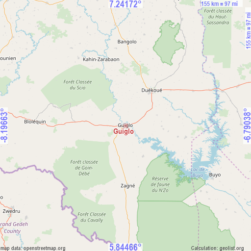
Guiglo GPS coordinates[2]
6° 32' 37.248" North, 7° 29' 36.6" West
| Map corner | latitude | longitude |
|---|---|---|
| Upper-left | 7.24172°, | -8.19663° |
| Center: | 6.54368°, | -7.4935° |
| Lower-right: | 5.84466°, | -6.79038° |
| Map W x H: | 155.3×155.3 km | = 96.5×96.5mi |
| max Lat: | 10.48115° ⇑62.4% North |
| Guiglo: | 6.54368° |
| min Lat: | ⇓37.6% South 4.42295° |
| min Long | Guiglo | max Long |
| -8.42592° | -7.4935° | -2.80003° |
| W 12.8%⇐ | ⇒87.2% E |
Elevation
Elevation of Guiglo is 212 m = 696 ft, and this is 12.3 m = 40 ft below average elevation for this country.
| Max E: |
556 m = 1824 ft | 53% |
| Avg. | 224.3 m = 736 ft | |
| Guiglo | 212 m = 696 ft | |
Min E: |
7 m = 23 ft | 47% |
See also: Ivory Coast elevation on elevation.city.
Geographical zone
Guiglo is located in North Torrid zone (between Equator and Tropic of Cancer). Distance of Equator is 727.6 km =452.1 mi to South.| Distance of | km | miles | from Guiglo |
|---|---|---|---|
| North Pole | 9279.5 | 5766 | to North |
| Arctic Circle | 6673.6 | 4146.8 | to North |
| Tropic Cancer | 1878.3 | 1167.1 | to North |
| Equator | 727.6 | 452.1 | to South |


Nearby cities:
15 places around Guiglo: (largest is in red/bold)
• Bangolo
52.1 km =32.4 mi,  0°
0°
• Bloléquin
56.3 km =35 mi,  272°
272°
• Buyo
62.4 km =38.8 mi,  118°
118°
• Daloa
121 km =75.2 mi,  72°
72°
• Danané
108 km =67.1 mi,  317°
317°
• Duekoué
27.2 km =16.9 mi,  35°
35°
• Facobly
94.8 km =58.9 mi,  7°
7°
• Issia
100.5 km =62.4 mi,  93°
93°
• Kouibly
84.2 km =52.3 mi,  19°
19°
• Man
96.8 km =60.1 mi,  356°
356°
• Taï
74.6 km =46.4 mi,  176°
176°
• Toulépleu
101.4 km =63 mi, 272°
• Toulépleu Gueré
103.1 km =64.1 mi, 271°
• Zouan-Hounien
89.1 km =55.4 mi,  297°
297°
• Zoukougbeu
73.7 km =45.8 mi, 70°
Sources, notices
• [Note1] Compared only with cities in Ivory Coast existing in our database
• [Src1] Map data: © OpenStreetMap contributors (CC-BY-SA)
• [Src2] Other city data from geonames.org with taken over terms of usage.
• [Src3] Geographical zone / Annual Mean Temperature by Robert A. Rohde @ Wikipedia
