Kouibly geodata
Kouibly (Montagnes) is a seat of a third-order administrative division; located in Ivory Coast in Africa/Abidjan (GMT+0) time zone. In our database, there are 63 cities with bigger population. Compared to other cities in Ivory Coast, 57.3% of cities are located further ↓South; 81.2% of cities are located further →East and 69.2% of cities have lower elevation than Kouibly. Note1


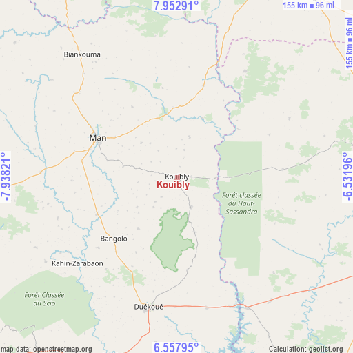
Kouibly GPS coordinates[2]
7° 15' 21.492" North, 7° 14' 6.288" West
| Map corner | latitude | longitude |
|---|---|---|
| Upper-left | 7.95291°, | -7.93821° |
| Center: | 7.25597°, | -7.23508° |
| Lower-right: | 6.55795°, | -6.53196° |
| Map W x H: | 155.1×155.1 km | = 96.4×96.4mi |
| max Lat: | 10.48115° ⇑42.7% North |
| Kouibly: | 7.25597° |
| min Lat: | ⇓57.3% South 4.42295° |
| min Long | Kouibly | max Long |
| -8.42592° | -7.23508° | -2.80003° |
| W 18.8%⇐ | ⇒81.2% E |
Elevation
Elevation of Kouibly is 307 m = 1007 ft, and this is 82.7 m = 271 ft above average elevation for this country.
| Max E: |
556 m = 1824 ft | 30.8% |
| Kouibly | 307 m 1007 ft | |
| Avg. | 224.3 m = 736 ft | |
Min E: |
7 m = 23 ft | 69.2% |
See also: Ivory Coast elevation on elevation.city.
Geographical zone
Kouibly is located in North Torrid zone (between Equator and Tropic of Cancer). Distance of Equator is 806.8 km =501.3 mi to South.| Distance of | km | miles | from Kouibly |
|---|---|---|---|
| North Pole | 9200.3 | 5716.8 | to North |
| Arctic Circle | 6594.4 | 4097.6 | to North |
| Tropic Cancer | 1799.1 | 1117.9 | to North |
| Equator | 806.8 | 501.3 | to South |


Nearby cities:
15 places around Kouibly: (largest is in red/bold)
• Bangolo
38.8 km =24.1 mi,  225°
225°
• Biankouma
68 km =42.3 mi,  322°
322°
• Bloléquin
114.1 km =70.9 mi, 227°
• Buyo
112.2 km =69.7 mi,  166°
166°
• Daloa
96.3 km =59.8 mi,  115°
115°
• Danané
101.5 km =63.1 mi,  270°
270°
• Duekoué
58.5 km =36.4 mi,  192°
192°
• Facobly
21.4 km =13.3 mi,  313°
313°
• Guiglo
84.2 km =52.3 mi,  199°
199°
• Issia
111.1 km =69 mi,  139°
139°
• Man
39.2 km =24.4 mi,  296°
296°
• Séguéla
99.9 km =62.1 mi,  38°
38°
• Vavoua
84.7 km =52.6 mi,  80°
80°
• Zouan-Hounien
113.5 km =70.5 mi,  250°
250°
• Zoukougbeu
68.5 km =42.6 mi, 143°
Sources, notices
• [Note1] Compared only with cities in Ivory Coast existing in our database
• [Src1] Map data: © OpenStreetMap contributors (CC-BY-SA)
• [Src2] Other city data from geonames.org with taken over terms of usage.
• [Src3] Geographical zone / Annual Mean Temperature by Robert A. Rohde @ Wikipedia
