Zoukougbeu geodata
Zoukougbeu (Sassandra-Marahoué) is a seat of a third-order administrative division; located in Ivory Coast in Africa/Abidjan (GMT+0) time zone. In our database, there are 63 cities with bigger population. Compared to other cities in Ivory Coast, 53% of cities are located further ↑North; 77.8% of cities are located further →East and 58.1% of cities have lower elevation than Zoukougbeu. Note1


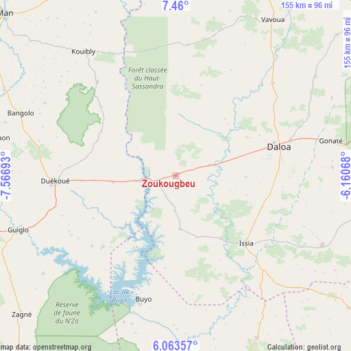
Zoukougbeu GPS coordinates[2]
6° 45' 44.244" North, 6° 51' 49.68" West
| Map corner | latitude | longitude |
|---|---|---|
| Upper-left | 7.46°, | -7.56693° |
| Center: | 6.76229°, | -6.8638° |
| Lower-right: | 6.06357°, | -6.16068° |
| Map W x H: | 155.3×155.3 km | = 96.5×96.5mi |
| max Lat: | 10.48115° ⇑53% North |
| Zoukougbeu: | 6.76229° |
| min Lat: | ⇓47% South 4.42295° |
| min Long | Zoukougbeu | max Long |
| -8.42592° | -6.8638° | -2.80003° |
| W 22.2%⇐ | ⇒77.8% E |
Elevation
Elevation of Zoukougbeu is 244 m = 801 ft, and this is 19.7 m = 65 ft above average elevation for this country.
| Max E: |
556 m = 1824 ft | 41.9% |
| Zoukougbeu | 244 m 801 ft | |
| Avg. | 224.3 m = 736 ft | |
Min E: |
7 m = 23 ft | 58.1% |
See also: Ivory Coast elevation on elevation.city.
Geographical zone
Zoukougbeu is located in North Torrid zone (between Equator and Tropic of Cancer). Distance of Equator is 751.9 km =467.2 mi to South.| Distance of | km | miles | from Zoukougbeu |
|---|---|---|---|
| North Pole | 9255.2 | 5750.9 | to North |
| Arctic Circle | 6649.3 | 4131.7 | to North |
| Tropic Cancer | 1854 | 1152 | to North |
| Equator | 751.9 | 467.2 | to South |


Nearby cities:
15 places around Zoukougbeu: (largest is in red/bold)
• Bangolo
74.1 km =46 mi,  292°
292°
• Buyo
56.1 km =34.9 mi,  195°
195°
• Daloa
47.4 km =29.5 mi,  74°
74°
• Duekoué
53.6 km =33.3 mi,  267°
267°
• Facobly
89.7 km =55.7 mi,  320°
320°
• Guibéroua
96.1 km =59.7 mi,  127°
127°
• Guiglo
73.7 km =45.8 mi,  250°
250°
• Issia
43 km =26.7 mi, 134°
• Kouibly
68.5 km =42.6 mi, 323°
• Man
105 km =65.2 mi,  313°
313°
• Sinfra
106.3 km =66.1 mi,  98°
98°
• Soubré
112.8 km =70.1 mi,  164°
164°
• Taï
118.5 km =73.6 mi,  213°
213°
• Vavoua
81 km =50.3 mi,  31°
31°
• Zuénoula
116.5 km =72.4 mi,  50°
50°
Sources, notices
• [Note1] Compared only with cities in Ivory Coast existing in our database
• [Src1] Map data: © OpenStreetMap contributors (CC-BY-SA)
• [Src2] Other city data from geonames.org with taken over terms of usage.
• [Src3] Geographical zone / Annual Mean Temperature by Robert A. Rohde @ Wikipedia
