Obala geodata
Obala (Centre) is a populated place; located in Cameroon in Africa/Douala (GMT+1) time zone. With population of 30,012 people, there are 47 cities with bigger population in this country. Compared to other cities in Cameroon, 74.6% of cities are located further ↑North; 62.3% of cities are located further ←West and 58.2% of cities have higher elevation than Obala. Note1


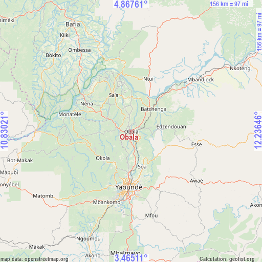
Obala GPS coordinates[2]
4° 10' 0.012" North, 11° 31' 59.988" East
| Map corner | latitude | longitude |
|---|---|---|
| Upper-left | 4.86761°, | 10.83021° |
| Center: | 4.16667°, | 11.53333° |
| Lower-right: | 3.46511°, | 12.23646° |
| Map W x H: | 155.9×155.9 km | = 96.9×96.9mi |
| max Lat: | 12.57535° ⇑74.6% North |
| Obala: | 4.16667° |
| min Lat: | ⇓25.4% South 2.35° |
| min Long | Obala | max Long |
| 8.8724° | 11.53333° | 15.23288° |
| W 62.3%⇐ | ⇒37.7% E |
Elevation
Elevation of Obala is 542 m = 1778 ft, and this is 131.9 m = 433 ft below average elevation for this country.
| Max E: |
1687 m = 5535 ft | 58.2% |
| Avg. | 673.9 m = 2211 ft | |
| Obala | 542 m = 1778 ft | |
Min E: |
1 m = 3 ft | 41.8% |
See also: Cameroon elevation on elevation.city.
Geographical zone
Obala is located in North Torrid zone (between Equator and Tropic of Cancer). Distance of Equator is 463.3 km =287.9 mi to South.| Distance of | km | miles | from Obala |
|---|---|---|---|
| North Pole | 9543.8 | 5930.2 | to North |
| Arctic Circle | 6937.9 | 4311 | to North |
| Tropic Cancer | 2142.6 | 1331.3 | to North |
| Equator | 463.3 | 287.9 | to South |


Nearby cities:
15 places around Obala: (largest is in red/bold)
• Akono
77.4 km =48.1 mi,  196°
196°
• Bafia
72.9 km =45.3 mi,  332°
332°
• Essé
41.3 km =25.7 mi,  100°
100°
• Mbalmayo
72.4 km =45 mi,  182°
182°
• Mbandjok
51.4 km =31.9 mi,  52°
52°
• Mbankomo
45.8 km =28.5 mi, 201°
• Ngoro
88.7 km =55.1 mi,  349°
349°
• Nkoteng
67.7 km =42.1 mi, 54°
• Ntui
33.4 km =20.8 mi,  19°
19°
• Okoa
21.7 km =13.5 mi,  160°
160°
• Okola
23.6 km =14.7 mi,  224°
224°
• Ombésa
57.5 km =35.7 mi, 326°
• Saa
24.1 km =15 mi,  337°
337°
• Yaoundé
33.4 km =20.8 mi, 183°
• Évodoula
38.1 km =23.7 mi,  255°
255°
Sources, notices
• [Note1] Compared only with cities in Cameroon existing in our database
• [Src1] Map data: © OpenStreetMap contributors (CC-BY-SA)
• [Src2] Other city data from geonames.org with taken over terms of usage.
• [Src3] Geographical zone / Annual Mean Temperature by Robert A. Rohde @ Wikipedia
