Mbalmayo geodata
Mbalmayo (Centre) is a populated place; located in Cameroon in Africa/Douala (GMT+1) time zone. With population of 80,206 people, there are 22 cities with bigger population in this country. Compared to other cities in Cameroon, 91.8% of cities are located further ↑North; 59.8% of cities are located further ←West and 55.7% of cities have lower elevation than Mbalmayo. Note1


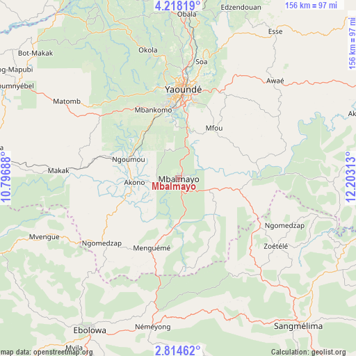
Mbalmayo GPS coordinates[2]
3° 31' 0.012" North, 11° 30' 0" East
| Map corner | latitude | longitude |
|---|---|---|
| Upper-left | 4.21819°, | 10.79688° |
| Center: | 3.51667°, | 11.5° |
| Lower-right: | 2.81462°, | 12.20313° |
| Map W x H: | 156.1×156.1 km | = 97×97mi |
| max Lat: | 12.57535° ⇑91.8% North |
| Mbalmayo: | 3.51667° |
| min Lat: | ⇓8.2% South 2.35° |
| min Long | Mbalmayo | max Long |
| 8.8724° | 11.5° | 15.23288° |
| W 59.8%⇐ | ⇒40.2% E |
Elevation
Elevation of Mbalmayo is 663 m = 2175 ft, and this is 10.9 m = 36 ft below average elevation for this country.
| Max E: |
1687 m = 5535 ft | 44.3% |
| Avg. | 673.9 m = 2211 ft | |
| Mbalmayo | 663 m = 2175 ft | |
Min E: |
1 m = 3 ft | 55.7% |
See also: Mbalmayo elevation on elevation.city.
Geographical zone
Mbalmayo is located in North Torrid zone (between Equator and Tropic of Cancer). Distance of Equator is 391 km =243 mi to South.| Distance of | km | miles | from Mbalmayo |
|---|---|---|---|
| North Pole | 9616 | 5975.1 | to North |
| Arctic Circle | 7010.2 | 4355.9 | to North |
| Tropic Cancer | 2214.9 | 1376.3 | to North |
| Equator | 391 | 243 | to South |


Nearby cities:
15 places around Mbalmayo: (largest is in red/bold)
• Akono
18.6 km =11.6 mi,  264°
264°
• Akonolinga
87.7 km =54.5 mi,  71°
71°
• Essé
78.6 km =48.8 mi,  34°
34°
• Eséka
82.7 km =51.4 mi,  280°
280°
• Lolodorf
90.7 km =56.4 mi,  249°
249°
• Mbankomo
32.4 km =20.1 mi,  336°
336°
• Mvangué
61.2 km =38 mi,  178°
178°
• Ngomedzap
44.6 km =27.7 mi,  228°
228°
• Obala
72.4 km =45 mi,  2°
2°
• Okoa
53.1 km =33 mi,  12°
12°
• Okola
57.1 km =35.5 mi,  346°
346°
• Sangmélima
84.2 km =52.3 mi,  140°
140°
• Yaoundé
39 km =24.2 mi, 2°
• Ébolowa
78.8 km =49 mi,  209°
209°
• Évodoula
71.3 km =44.3 mi,  332°
332°
Sources, notices
• [Note1] Compared only with cities in Cameroon existing in our database
• [Src1] Map data: © OpenStreetMap contributors (CC-BY-SA)
• [Src2] Other city data from geonames.org with taken over terms of usage.
• [Src3] Geographical zone / Annual Mean Temperature by Robert A. Rohde @ Wikipedia
