Ombésa geodata
Ombésa (Centre) is a populated place; located in Cameroon in Africa/Douala (GMT+1) time zone. With population of 1,833 people, there are 118 cities with bigger population in this country. Compared to other cities in Cameroon, 59% of cities are located further ↑North; 52.5% of cities are located further ←West and 68.9% of cities have higher elevation than Ombésa. Note1


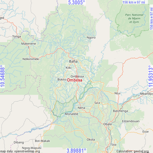
Ombésa GPS coordinates[2]
4° 36' 0" North, 11° 15' 0" East
| Map corner | latitude | longitude |
|---|---|---|
| Upper-left | 5.3005°, | 10.54688° |
| Center: | 4.6°, | 11.25° |
| Lower-right: | 3.89881°, | 11.95313° |
| Map W x H: | 155.9×155.9 km | = 96.9×96.9mi |
| max Lat: | 12.57535° ⇑59% North |
| Ombésa: | 4.6° |
| min Lat: | ⇓41% South 2.35° |
| min Long | Ombésa | max Long |
| 8.8724° | 11.25° | 15.23288° |
| W 52.5%⇐ | ⇒47.5% E |
Elevation
Elevation of Ombésa is 459 m = 1506 ft, and this is 214.9 m = 705 ft below average elevation for this country.
| Max E: |
1687 m = 5535 ft | 68.9% |
| Avg. | 673.9 m = 2211 ft | |
| Ombésa | 459 m = 1506 ft | |
Min E: |
1 m = 3 ft | 31.1% |
See also: Cameroon elevation on elevation.city.
Geographical zone
Ombésa is located in North Torrid zone (between Equator and Tropic of Cancer). Distance of Equator is 511.5 km =317.8 mi to South.| Distance of | km | miles | from Ombésa |
|---|---|---|---|
| North Pole | 9495.6 | 5900.3 | to North |
| Arctic Circle | 6889.7 | 4281.1 | to North |
| Tropic Cancer | 2094.4 | 1301.4 | to North |
| Equator | 511.5 | 317.8 | to South |


Nearby cities:
15 places around Ombésa: (largest is in red/bold)
• Bafia
16.8 km =10.4 mi,  353°
353°
• Essé
91 km =56.5 mi,  127°
127°
• Mbandjok
74 km =46 mi,  103°
103°
• Ndikiniméki
49.8 km =30.9 mi,  291°
291°
• Ngambé
81.3 km =50.5 mi,  239°
239°
• Ngoro
41.6 km =25.8 mi,  20°
20°
• Nkoteng
87.3 km =54.2 mi, 96°
• Ntui
45.6 km =28.3 mi,  111°
111°
• Obala
57.5 km =35.7 mi,  146°
146°
• Okoa
78.8 km =49 mi, 150°
• Okola
66.5 km =41.3 mi,  167°
167°
• Saa
34.1 km =21.2 mi,  139°
139°
• Tonga
73.3 km =45.5 mi,  303°
303°
• Yaoundé
86.7 km =53.9 mi,  160°
160°
• Évodoula
57.7 km =35.9 mi,  185°
185°
Sources, notices
• [Note1] Compared only with cities in Cameroon existing in our database
• [Src1] Map data: © OpenStreetMap contributors (CC-BY-SA)
• [Src2] Other city data from geonames.org with taken over terms of usage.
• [Src3] Geographical zone / Annual Mean Temperature by Robert A. Rohde @ Wikipedia
