Mbankomo geodata
Mbankomo (Centre) is a populated place; located in Cameroon in Africa/Douala (GMT+1) time zone. With population of 2,387 people, there are 113 cities with bigger population in this country. Compared to other cities in Cameroon, 86.9% of cities are located further ↑North; 54.9% of cities are located further ←West and 64.8% of cities have lower elevation than Mbankomo. Note1


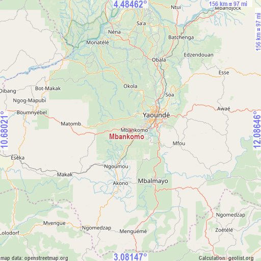
Mbankomo GPS coordinates[2]
3° 46' 59.988" North, 11° 22' 59.988" East
| Map corner | latitude | longitude |
|---|---|---|
| Upper-left | 4.48462°, | 10.68021° |
| Center: | 3.78333°, | 11.38333° |
| Lower-right: | 3.08147°, | 12.08646° |
| Map W x H: | 156×156 km | = 96.9×96.9mi |
| max Lat: | 12.57535° ⇑86.9% North |
| Mbankomo: | 3.78333° |
| min Lat: | ⇓13.1% South 2.35° |
| min Long | Mbankomo | max Long |
| 8.8724° | 11.38333° | 15.23288° |
| W 54.9%⇐ | ⇒45.1% E |
Elevation
Elevation of Mbankomo is 732 m = 2402 ft, and this is 58.1 m = 191 ft above average elevation for this country.
| Max E: |
1687 m = 5535 ft | 35.2% |
| Mbankomo | 732 m 2402 ft | |
| Avg. | 673.9 m = 2211 ft | |
Min E: |
1 m = 3 ft | 64.8% |
See also: Cameroon elevation on elevation.city.
Geographical zone
Mbankomo is located in North Torrid zone (between Equator and Tropic of Cancer). Distance of Equator is 420.7 km =261.4 mi to South.| Distance of | km | miles | from Mbankomo |
|---|---|---|---|
| North Pole | 9586.4 | 5956.7 | to North |
| Arctic Circle | 6980.5 | 4337.5 | to North |
| Tropic Cancer | 2185.3 | 1357.9 | to North |
| Equator | 420.7 | 261.4 | to South |


Nearby cities:
15 places around Mbankomo: (largest is in red/bold)
• Akono
32 km =19.9 mi,  189°
189°
• Essé
67.3 km =41.8 mi,  58°
58°
• Eséka
70 km =43.5 mi,  257°
257°
• Mbalmayo
32.4 km =20.1 mi,  156°
156°
• Mbandjok
93.7 km =58.2 mi,  37°
37°
• Mvangué
92 km =57.2 mi,  170°
170°
• Ngomedzap
62.7 km =39 mi,  198°
198°
• Ntui
79.1 km =49.2 mi,  20°
20°
• Obala
45.8 km =28.5 mi, 21°
• Okoa
32.7 km =20.3 mi,  47°
47°
• Okola
25.9 km =16.1 mi,  0°
0°
• Ombésa
92 km =57.2 mi,  350°
350°
• Saa
65.3 km =40.6 mi,  6°
6°
• Yaoundé
17.5 km =10.9 mi, 57°
• Évodoula
39.1 km =24.3 mi,  328°
328°
Sources, notices
• [Note1] Compared only with cities in Cameroon existing in our database
• [Src1] Map data: © OpenStreetMap contributors (CC-BY-SA)
• [Src2] Other city data from geonames.org with taken over terms of usage.
• [Src3] Geographical zone / Annual Mean Temperature by Robert A. Rohde @ Wikipedia
