Yaoundé geodata
Yaoundé (Centre) is a capital of a political entity; located in Cameroon in Africa/Douala (GMT+1) time zone. With population of 1,299,369 people, there is 1 city with bigger population in this country. Compared to other cities in Cameroon, 85.2% of cities are located further ↑North; 60.7% of cities are located further ←West and 63.1% of cities have lower elevation than Yaoundé. Note1


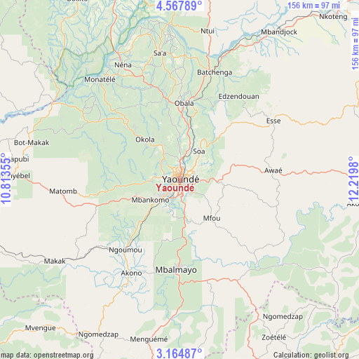
Yaoundé GPS coordinates[2]
3° 52' 0.012" North, 11° 31' 0.012" East
| Map corner | latitude | longitude |
|---|---|---|
| Upper-left | 4.56789°, | 10.81355° |
| Center: | 3.86667°, | 11.51667° |
| Lower-right: | 3.16487°, | 12.2198° |
| Map W x H: | 156×156 km | = 96.9×96.9mi |
| max Lat: | 12.57535° ⇑85.2% North |
| Yaoundé: | 3.86667° |
| min Lat: | ⇓14.8% South 2.35° |
| min Long | Yaoundé | max Long |
| 8.8724° | 11.51667° | 15.23288° |
| W 60.7%⇐ | ⇒39.3% E |
Elevation
Elevation of Yaoundé is 726 m = 2382 ft, and this is 52.1 m = 171 ft above average elevation for this country.
| Max E: |
1687 m = 5535 ft | 36.9% |
| Yaoundé | 726 m 2382 ft | |
| Avg. | 673.9 m = 2211 ft | |
Min E: |
1 m = 3 ft | 63.1% |
See also: Yaoundé elevation on elevation.city.
Geographical zone
Yaoundé is located in North Torrid zone (between Equator and Tropic of Cancer). Distance of Equator is 429.9 km =267.1 mi to South.| Distance of | km | miles | from Yaoundé |
|---|---|---|---|
| North Pole | 9577.1 | 5950.9 | to North |
| Arctic Circle | 6971.2 | 4331.7 | to North |
| Tropic Cancer | 2176 | 1352.1 | to North |
| Equator | 429.9 | 267.1 | to South |


Nearby cities:
15 places around Yaoundé: (largest is in red/bold)
• Akono
45.6 km =28.3 mi,  206°
206°
• Akonolinga
82.1 km =51 mi,  97°
97°
• Essé
49.8 km =30.9 mi,  58°
58°
• Eséka
86.6 km =53.8 mi,  253°
253°
• Mbalmayo
39 km =24.2 mi,  182°
182°
• Mbandjok
77.5 km =48.2 mi,  33°
33°
• Mbankomo
17.5 km =10.9 mi,  237°
237°
• Ngomedzap
77 km =47.8 mi, 207°
• Ntui
66.1 km =41.1 mi,  11°
11°
• Obala
33.4 km =20.8 mi,  3°
3°
• Okoa
15.9 km =9.9 mi,  35°
35°
• Okola
22.3 km =13.9 mi,  318°
318°
• Ombésa
86.7 km =53.9 mi,  340°
340°
• Saa
56.1 km =34.9 mi,  352°
352°
• Évodoula
42.6 km =26.5 mi,  304°
304°
Sources, notices
• [Note1] Compared only with cities in Cameroon existing in our database
• [Src1] Map data: © OpenStreetMap contributors (CC-BY-SA)
• [Src2] Other city data from geonames.org with taken over terms of usage.
• [Src3] Geographical zone / Annual Mean Temperature by Robert A. Rohde @ Wikipedia
