Shangping geodata
Shangping (Guangdong) is a seat of a fourth-order administrative division; located in China in Asia/Shanghai (GMT+8) time zone. In our database, there are 1268 cities with bigger population. Compared to other cities in China, 87.6% of cities are located further ↑North; 56.7% of cities are located further ←West and 58.2% of cities have lower elevation than Shangping. Note1


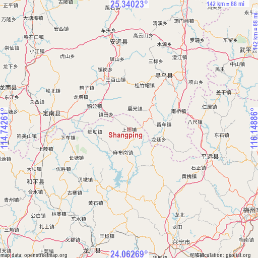
Shangping GPS coordinates[2]
24° 42' 11.16" North, 115° 26' 44.628" East
| Map corner | latitude | longitude |
|---|---|---|
| Upper-left | 25.34023°, | 114.74261° |
| Center: | 24.7031°, | 115.44573° |
| Lower-right: | 24.06269°, | 116.14886° |
| Map W x H: | 142×142.1 km | = 88.2×88.3mi |
| max Lat: | 53.31946° ⇑87.6% North |
| Shangping: | 24.7031° |
| min Lat: | ⇓12.4% South 18.22056° |
| min Long | Shangping | max Long |
| 75.07348° | 115.44573° | 134.28917° |
| W 56.7%⇐ | ⇒43.3% E |
Elevation
Elevation of Shangping is 238 m = 781 ft, and this is 246.8 m = 810 ft below average elevation for this country.
| Max E: |
5622 m = 18445 ft | 41.8% |
| Avg. | 484.8 m = 1591 ft | |
| Shangping | 238 m = 781 ft | |
Min E: |
-3 m = -10 ft | 58.2% |
See also: China elevation on elevation.city.
Geographical zone
Shangping is located in North temperate zone (between Tropic of Cancer and the Arctic Circle). Distance of this Northern Tropic circle is 140.8 km =87.5 mi to South.| Distance of | km | miles | from Shangping |
|---|---|---|---|
| North Pole | 7260.3 | 4511.3 | to North |
| Arctic Circle | 4654.4 | 2892.1 | to North |
| Tropic Cancer | 140.8 | 87.5 | to South |
| Equator | 2746.7 | 1706.7 | to South |


Nearby cities:
15 places around Shangping: (largest is in red/bold)
• Beiling
16.1 km =10 mi,  222°
222°
• Changpu
8.9 km =5.5 mi,  61°
61°
• Chenguang
12 km =7.5 mi,  15°
15°
• Guizhumao
25.8 km =16 mi, 19°
• Kongtian
28.4 km =17.6 mi,  330°
330°
• Liuche
19.4 km =12.1 mi,  81°
81°
• Longting
17.1 km =10.6 mi,  108°
108°
• Luofu
23.8 km =14.8 mi,  145°
145°
• Mabugang
13.1 km =8.1 mi,  194°
194°
• Nanqiao
29 km =18 mi,  69°
69°
• Sanbaishan
28.5 km =17.7 mi,  344°
344°
• Xintian
28.4 km =17.6 mi,  164°
164°
• Xi’ao
18.6 km =11.6 mi,  265°
265°
• Yanzhen
23.8 km =14.8 mi,  178°
178°
• Zhentian
15.3 km =9.5 mi,  303°
303°
Sources, notices
• [Note1] Compared only with cities in China existing in our database
• [Src1] Map data: © OpenStreetMap contributors (CC-BY-SA)
• [Src2] Other city data from geonames.org with taken over terms of usage.
• [Src3] Geographical zone / Annual Mean Temperature by Robert A. Rohde @ Wikipedia
