Hangkou geodata
Hangkou (Jiangxi) is a seat of a fourth-order administrative division; located in China in Asia/Shanghai (GMT+8) time zone. In our database, there are 1268 cities with bigger population. Compared to other cities in China, 64.9% of cities are located further ↑North; 51.2% of cities are located further ←West and 59.4% of cities have higher elevation than Hangkou. Note1


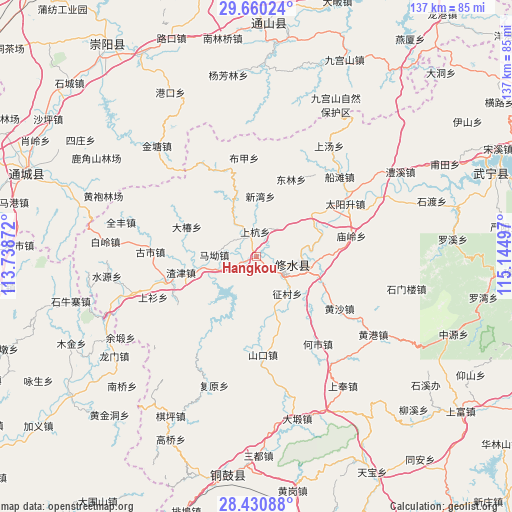
Hangkou GPS coordinates[2]
29° 2' 50.604" North, 114° 26' 30.624" East
| Map corner | latitude | longitude |
|---|---|---|
| Upper-left | 29.66024°, | 113.73872° |
| Center: | 29.04739°, | 114.44184° |
| Lower-right: | 28.43088°, | 115.14497° |
| Map W x H: | 136.7×136.7 km | = 84.9×84.9mi |
| max Lat: | 53.31946° ⇑64.9% North |
| Hangkou: | 29.04739° |
| min Lat: | ⇓35.1% South 18.22056° |
| min Long | Hangkou | max Long |
| 75.07348° | 114.44184° | 134.28917° |
| W 51.2%⇐ | ⇒48.8% E |
Elevation
Elevation of Hangkou is 102 m = 335 ft, and this is 382.8 m = 1256 ft below average elevation for this country.
| Max E: |
5622 m = 18445 ft | 59.4% |
| Avg. | 484.8 m = 1591 ft | |
| Hangkou | 102 m = 335 ft | |
Min E: |
-3 m = -10 ft | 40.6% |
See also: China elevation on elevation.city.
Geographical zone
Hangkou is located in North temperate zone (between Tropic of Cancer and the Arctic Circle). Distance of this Northern Tropic circle is 623.8 km =387.6 mi to South.| Distance of | km | miles | from Hangkou |
|---|---|---|---|
| North Pole | 6777.3 | 4211.2 | to North |
| Arctic Circle | 4171.4 | 2592 | to North |
| Tropic Cancer | 623.8 | 387.6 | to South |
| Equator | 3229.8 | 2006.9 | to South |


Nearby cities:
15 places around Hangkou: (largest is in red/bold)
• Chengfang
12 km =7.5 mi,  229°
229°
• Dachun
20.2 km =12.6 mi,  293°
293°
• Donggang
24.3 km =15.1 mi,  239°
239°
• Donglin
22.8 km =14.2 mi,  24°
24°
• Manjiang
25.2 km =15.7 mi,  188°
188°
• Ma’ao
11.2 km =7 mi,  274°
274°
• Shanghang
6.6 km =4.1 mi,  356°
356°
• Sidu
18.5 km =11.5 mi,  51°
51°
• Xigang
6.3 km =3.9 mi,  321°
321°
• Xikou
14.4 km =8.9 mi,  333°
333°
• Xinwan
16.3 km =10.1 mi,  4°
4°
• Yining
11.9 km =7.4 mi,  96°
96°
• Zhajin
20.5 km =12.7 mi,  258°
258°
• Zhengcun
13.4 km =8.3 mi,  140°
140°
• Zhuping
5.1 km =3.2 mi, 141°
Sources, notices
• [Note1] Compared only with cities in China existing in our database
• [Src1] Map data: © OpenStreetMap contributors (CC-BY-SA)
• [Src2] Other city data from geonames.org with taken over terms of usage.
• [Src3] Geographical zone / Annual Mean Temperature by Robert A. Rohde @ Wikipedia
