Yining geodata
Yining (Jiangxi) is a seat of a third-order administrative division; located in China in Asia/Shanghai (GMT+8) time zone. In our database, there are 1268 cities with bigger population. Compared to other cities in China, 65% of cities are located further ↑North; 51.9% of cities are located further ←West and 57.9% of cities have higher elevation than Yining. Note1


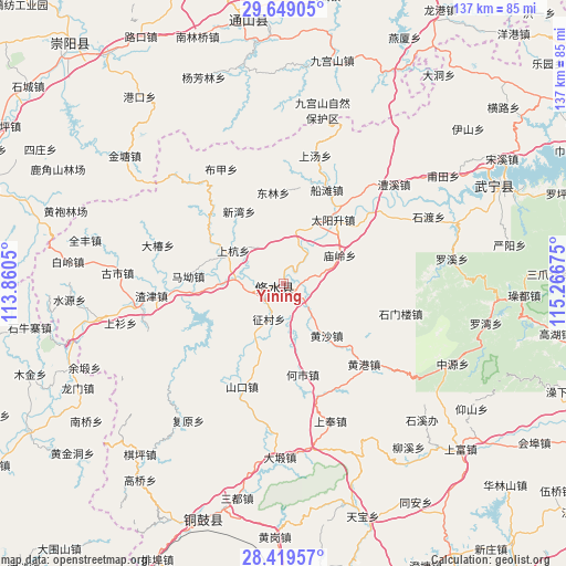
Yining GPS coordinates[2]
29° 2' 10.104" North, 114° 33' 49.032" East
| Map corner | latitude | longitude |
|---|---|---|
| Upper-left | 29.64905°, | 113.8605° |
| Center: | 29.03614°, | 114.56362° |
| Lower-right: | 28.41957°, | 115.26675° |
| Map W x H: | 136.7×136.7 km | = 84.9×84.9mi |
| max Lat: | 53.31946° ⇑65% North |
| Yining: | 29.03614° |
| min Lat: | ⇓35% South 18.22056° |
| min Long | Yining | max Long |
| 75.07348° | 114.56362° | 134.28917° |
| W 51.9%⇐ | ⇒48.1% E |
Elevation
Elevation of Yining is 112 m = 367 ft, and this is 372.8 m = 1223 ft below average elevation for this country.
| Max E: |
5622 m = 18445 ft | 57.9% |
| Avg. | 484.8 m = 1591 ft | |
| Yining | 112 m = 367 ft | |
Min E: |
-3 m = -10 ft | 42.1% |
See also: China elevation on elevation.city.
Geographical zone
Yining is located in North temperate zone (between Tropic of Cancer and the Arctic Circle). Distance of this Northern Tropic circle is 622.6 km =386.9 mi to South.| Distance of | km | miles | from Yining |
|---|---|---|---|
| North Pole | 6778.5 | 4212 | to North |
| Arctic Circle | 4172.7 | 2592.8 | to North |
| Tropic Cancer | 622.6 | 386.9 | to South |
| Equator | 3228.5 | 2006.1 | to South |


Nearby cities:
15 places around Yining: (largest is in red/bold)
• Chengfang
21.9 km =13.6 mi,  252°
252°
• Donglin
22.1 km =13.7 mi,  353°
353°
• Hangkou
11.9 km =7.4 mi,  276°
276°
• Heshi
22.3 km =13.9 mi,  168°
168°
• Huangsha
16.4 km =10.2 mi,  140°
140°
• Ma’ao
23.1 km =14.4 mi, 275°
• Miaoling
15.6 km =9.7 mi,  60°
60°
• Sandu
19.4 km =12.1 mi,  37°
37°
• Shanghang
14.6 km =9.1 mi,  302°
302°
• Sidu
13.1 km =8.1 mi,  11°
11°
• Xigang
16.9 km =10.5 mi,  291°
291°
• Xikou
23.1 km =14.4 mi,  307°
307°
• Xinwan
20.5 km =12.7 mi,  328°
328°
• Zhengcun
9.7 km =6 mi,  200°
200°
• Zhuping
9.1 km =5.7 mi, 252°
Sources, notices
• [Note1] Compared only with cities in China existing in our database
• [Src1] Map data: © OpenStreetMap contributors (CC-BY-SA)
• [Src2] Other city data from geonames.org with taken over terms of usage.
• [Src3] Geographical zone / Annual Mean Temperature by Robert A. Rohde @ Wikipedia
