Xigang geodata
Xigang (Jiangxi) is a seat of a fourth-order administrative division; located in China in Asia/Shanghai (GMT+8) time zone. In our database, there are 1268 cities with bigger population. Compared to other cities in China, 64.4% of cities are located further ↑North; 51% of cities are located further ←West and 57.2% of cities have higher elevation than Xigang. Note1


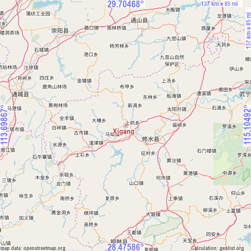
Xigang GPS coordinates[2]
29° 5' 31.56" North, 114° 24' 6.444" East
| Map corner | latitude | longitude |
|---|---|---|
| Upper-left | 29.70468°, | 113.69867° |
| Center: | 29.0921°, | 114.40179° |
| Lower-right: | 28.47586°, | 115.10492° |
| Map W x H: | 136.6×136.6 km | = 84.9×84.9mi |
| max Lat: | 53.31946° ⇑64.4% North |
| Xigang: | 29.0921° |
| min Lat: | ⇓35.6% South 18.22056° |
| min Long | Xigang | max Long |
| 75.07348° | 114.40179° | 134.28917° |
| W 51%⇐ | ⇒49% E |
Elevation
Elevation of Xigang is 116 m = 381 ft, and this is 368.8 m = 1210 ft below average elevation for this country.
| Max E: |
5622 m = 18445 ft | 57.2% |
| Avg. | 484.8 m = 1591 ft | |
| Xigang | 116 m = 381 ft | |
Min E: |
-3 m = -10 ft | 42.8% |
See also: China elevation on elevation.city.
Geographical zone
Xigang is located in North temperate zone (between Tropic of Cancer and the Arctic Circle). Distance of this Northern Tropic circle is 628.8 km =390.7 mi to South.| Distance of | km | miles | from Xigang |
|---|---|---|---|
| North Pole | 6772.3 | 4208.1 | to North |
| Arctic Circle | 4166.4 | 2588.9 | to North |
| Tropic Cancer | 628.8 | 390.7 | to South |
| Equator | 3234.7 | 2009.9 | to South |


Nearby cities:
15 places around Xigang: (largest is in red/bold)
• Bujia
21.6 km =13.4 mi,  2°
2°
• Chengfang
13.8 km =8.6 mi,  202°
202°
• Dachun
15 km =9.3 mi,  281°
281°
• Donglin
20.6 km =12.8 mi,  40°
40°
• Gangkou
19.6 km =12.2 mi,  339°
339°
• Hangkou
6.3 km =3.9 mi,  141°
141°
• Ma’ao
8.3 km =5.2 mi,  240°
240°
• Shanghang
3.9 km =2.4 mi,  64°
64°
• Sidu
19.5 km =12.1 mi,  70°
70°
• Xikou
8.3 km =5.2 mi, 342°
• Xinwan
12.3 km =7.6 mi,  24°
24°
• Yining
16.9 km =10.5 mi,  111°
111°
• Zhajin
18.5 km =11.5 mi, 240°
• Zhengcun
19.7 km =12.2 mi, 140°
• Zhuping
11.4 km =7.1 mi, 141°
Sources, notices
• [Note1] Compared only with cities in China existing in our database
• [Src1] Map data: © OpenStreetMap contributors (CC-BY-SA)
• [Src2] Other city data from geonames.org with taken over terms of usage.
• [Src3] Geographical zone / Annual Mean Temperature by Robert A. Rohde @ Wikipedia
