Zigong geodata
Zigong (Sichuan) is a populated place; located in China in Asia/Shanghai (GMT+8) time zone. With population of 689,961 people, there are 90 cities with bigger population in this country. Compared to other cities in China, 61.5% of cities are located further ↑North; 89.3% of cities are located further →East and 63.6% of cities have lower elevation than Zigong. Note1


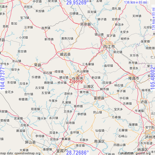
Zigong GPS coordinates[2]
29° 20' 29.832" North, 104° 46' 36.804" East
| Map corner | latitude | longitude |
|---|---|---|
| Upper-left | 29.95269°, | 104.07377° |
| Center: | 29.34162°, | 104.77689° |
| Lower-right: | 28.72686°, | 105.48002° |
| Map W x H: | 136.3×136.3 km | = 84.7×84.7mi |
| max Lat: | 53.31946° ⇑61.5% North |
| Zigong: | 29.34162° |
| min Lat: | ⇓38.5% South 18.22056° |
| min Long | Zigong | max Long |
| 75.07348° | 104.77689° | 134.28917° |
| W 10.7%⇐ | ⇒89.3% E |
Elevation
Elevation of Zigong is 306 m = 1004 ft, and this is 178.8 m = 587 ft below average elevation for this country.
| Max E: |
5622 m = 18445 ft | 36.4% |
| Avg. | 484.8 m = 1591 ft | |
| Zigong | 306 m = 1004 ft | |
Min E: |
-3 m = -10 ft | 63.6% |
See also: Zigong elevation on elevation.city.
Geographical zone
Zigong is located in North temperate zone (between Tropic of Cancer and the Arctic Circle). Distance of this Northern Tropic circle is 656.6 km =408 mi to South.| Distance of | km | miles | from Zigong |
|---|---|---|---|
| North Pole | 6744.6 | 4190.9 | to North |
| Arctic Circle | 4138.7 | 2571.7 | to North |
| Tropic Cancer | 656.6 | 408 | to South |
| Equator | 3262.5 | 2027.2 | to South |


Nearby cities:
15 places around Zigong: (largest is in red/bold)
• Chonglong
49.4 km =30.7 mi,  8°
8°
• Fuji
61.8 km =38.4 mi,  110°
110°
• Fushi
27.9 km =17.3 mi,  128°
128°
• Gongjing
6.4 km =4 mi,  275°
275°
• Jin’e
49.2 km =30.6 mi,  89°
89°
• Longji
62.3 km =38.7 mi,  77°
77°
• Nanxi
58.9 km =36.6 mi,  160°
160°
• Neijiang
38.6 km =24 mi,  45°
45°
• Panlong
60.2 km =37.4 mi,  72°
72°
• Qingliu
60.1 km =37.3 mi,  62°
62°
• Xuyang
37 km =23 mi,  290°
290°
• Yanling
23.8 km =14.8 mi,  331°
331°
• Yantan
12 km =7.5 mi, 128°
• Yibin
65.6 km =40.8 mi,  193°
193°
• Yuanjue
57.6 km =35.8 mi, 65°
Sources, notices
• [Note1] Compared only with cities in China existing in our database
• [Src1] Map data: © OpenStreetMap contributors (CC-BY-SA)
• [Src2] Other city data from geonames.org with taken over terms of usage.
• [Src3] Geographical zone / Annual Mean Temperature by Robert A. Rohde @ Wikipedia
