Neijiang geodata
Neijiang (Sichuan) is a seat of a third-order administrative division; located in China in Asia/Shanghai (GMT+8) time zone. With population of 546,854 people, there are 118 cities with bigger population in this country. Compared to other cities in China, 58.8% of cities are located further ↑North; 89% of cities are located further →East and 66.3% of cities have lower elevation than Neijiang. Note1


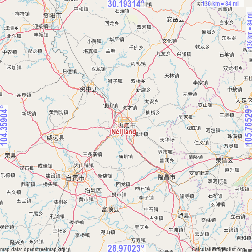
Neijiang GPS coordinates[2]
29° 35' 0.744" North, 105° 3' 43.776" East
| Map corner | latitude | longitude |
|---|---|---|
| Upper-left | 30.19314°, | 104.35904° |
| Center: | 29.58354°, | 105.06216° |
| Lower-right: | 28.97023°, | 105.76529° |
| Map W x H: | 136×136 km | = 84.5×84.5mi |
| max Lat: | 53.31946° ⇑58.8% North |
| Neijiang: | 29.58354° |
| min Lat: | ⇓41.2% South 18.22056° |
| min Long | Neijiang | max Long |
| 75.07348° | 105.06216° | 134.28917° |
| W 11%⇐ | ⇒89% E |
Elevation
Elevation of Neijiang is 349 m = 1145 ft, and this is 135.8 m = 446 ft below average elevation for this country.
| Max E: |
5622 m = 18445 ft | 33.7% |
| Avg. | 484.8 m = 1591 ft | |
| Neijiang | 349 m = 1145 ft | |
Min E: |
-3 m = -10 ft | 66.3% |
See also: Neijiang elevation on elevation.city.
Geographical zone
Neijiang is located in North temperate zone (between Tropic of Cancer and the Arctic Circle). Distance of this Northern Tropic circle is 683.5 km =424.7 mi to South.| Distance of | km | miles | from Neijiang |
|---|---|---|---|
| North Pole | 6717.7 | 4174.2 | to North |
| Arctic Circle | 4111.8 | 2555 | to North |
| Tropic Cancer | 683.5 | 424.7 | to South |
| Equator | 3289.4 | 2043.9 | to South |


Nearby cities:
15 places around Neijiang: (largest is in red/bold)
• Chonglong
29.9 km =18.6 mi,  317°
317°
• Gongjing
42.9 km =26.7 mi,  232°
232°
• Guansheng
36.3 km =22.6 mi,  91°
91°
• Jin’e
34.3 km =21.3 mi,  141°
141°
• Longji
35.8 km =22.2 mi,  112°
112°
• Panlong
31.2 km =19.4 mi, 107°
• Qingliu
25.7 km =16 mi, 88°
• Renyi
41.1 km =25.5 mi,  101°
101°
• Ronglong
40.8 km =25.4 mi, 113°
• Tonggu
39.2 km =24.4 mi, 86°
• Wujia
32.3 km =20.1 mi,  79°
79°
• Yanling
39.2 km =24.4 mi,  261°
261°
• Yantan
39 km =24.2 mi,  207°
207°
• Yuanjue
24.8 km =15.4 mi, 96°
• Zigong
38.6 km =24 mi, 225°
Sources, notices
• [Note1] Compared only with cities in China existing in our database
• [Src1] Map data: © OpenStreetMap contributors (CC-BY-SA)
• [Src2] Other city data from geonames.org with taken over terms of usage.
• [Src3] Geographical zone / Annual Mean Temperature by Robert A. Rohde @ Wikipedia
