Chonglong geodata
Chonglong (Sichuan) is a seat of a third-order administrative division; located in China in Asia/Shanghai (GMT+8) time zone. With population of 58,441 people, there are 753 cities with bigger population in this country. Compared to other cities in China, 56.5% of cities are located further ↑North; 89.2% of cities are located further →East and 67.1% of cities have lower elevation than Chonglong. Note1


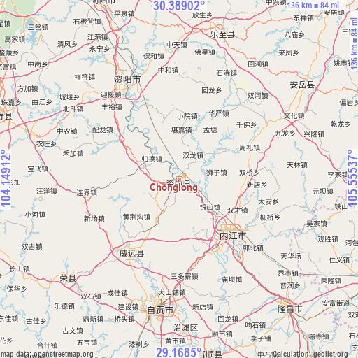
Chonglong GPS coordinates[2]
29° 46' 50.232" North, 104° 51' 8.064" East
| Map corner | latitude | longitude |
|---|---|---|
| Upper-left | 30.38902°, | 104.14912° |
| Center: | 29.78062°, | 104.85224° |
| Lower-right: | 29.1685°, | 105.55537° |
| Map W x H: | 135.7×135.7 km | = 84.3×84.3mi |
| max Lat: | 53.31946° ⇑56.5% North |
| Chonglong: | 29.78062° |
| min Lat: | ⇓43.5% South 18.22056° |
| min Long | Chonglong | max Long |
| 75.07348° | 104.85224° | 134.28917° |
| W 10.8%⇐ | ⇒89.2% E |
Elevation
Elevation of Chonglong is 361 m = 1184 ft, and this is 123.8 m = 406 ft below average elevation for this country.
| Max E: |
5622 m = 18445 ft | 32.9% |
| Avg. | 484.8 m = 1591 ft | |
| Chonglong | 361 m = 1184 ft | |
Min E: |
-3 m = -10 ft | 67.1% |
See also: Chonglong elevation on elevation.city.
Geographical zone
Chonglong is located in North temperate zone (between Tropic of Cancer and the Arctic Circle). Distance of this Northern Tropic circle is 705.4 km =438.3 mi to South.| Distance of | km | miles | from Chonglong |
|---|---|---|---|
| North Pole | 6695.8 | 4160.6 | to North |
| Arctic Circle | 4089.9 | 2541.3 | to North |
| Tropic Cancer | 705.4 | 438.3 | to South |
| Equator | 3311.3 | 2057.5 | to South |


Nearby cities:
15 places around Chonglong: (largest is in red/bold)
• Gongjing
50 km =31.1 mi,  195°
195°
• Guansheng
60.9 km =37.8 mi,  111°
111°
• Neijiang
29.9 km =18.6 mi,  137°
137°
• Panlong
59 km =36.7 mi,  121°
121°
• Qingliu
50.5 km =31.4 mi, 114°
• Tianchi
58 km =36 mi,  16°
16°
• Tieshan
63.5 km =39.5 mi,  99°
99°
• Tonggu
62.5 km =38.8 mi, 108°
• Wujia
54.5 km =33.9 mi, 107°
• Xuyang
55 km =34.2 mi,  229°
229°
• Yanjiang
42.7 km =26.5 mi,  332°
332°
• Yanling
33.4 km =20.8 mi,  213°
213°
• Yantan
56.4 km =35 mi,  177°
177°
• Yuanjue
51.3 km =31.9 mi, 118°
• Zigong
49.4 km =30.7 mi,  188°
188°
Sources, notices
• [Note1] Compared only with cities in China existing in our database
• [Src1] Map data: © OpenStreetMap contributors (CC-BY-SA)
• [Src2] Other city data from geonames.org with taken over terms of usage.
• [Src3] Geographical zone / Annual Mean Temperature by Robert A. Rohde @ Wikipedia
