Yibin geodata
Yibin (Sichuan) is a seat of a third-order administrative division; located in China in Asia/Shanghai (GMT+8) time zone. With population of 242,111 people, there are 207 cities with bigger population in this country. Compared to other cities in China, 67.3% of cities are located further ↑North; 89.5% of cities are located further →East and 62.6% of cities have lower elevation than Yibin. Note1


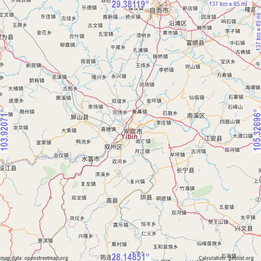
Yibin GPS coordinates[2]
28° 46' 0.012" North, 104° 37' 25.788" East
| Map corner | latitude | longitude |
|---|---|---|
| Upper-left | 29.38119°, | 103.92071° |
| Center: | 28.76667°, | 104.62383° |
| Lower-right: | 28.14851°, | 105.32696° |
| Map W x H: | 137.1×137.1 km | = 85.2×85.2mi |
| max Lat: | 53.31946° ⇑67.3% North |
| Yibin: | 28.76667° |
| min Lat: | ⇓32.7% South 18.22056° |
| min Long | Yibin | max Long |
| 75.07348° | 104.62383° | 134.28917° |
| W 10.5%⇐ | ⇒89.5% E |
Elevation
Elevation of Yibin is 291 m = 955 ft, and this is 193.8 m = 636 ft below average elevation for this country.
| Max E: |
5622 m = 18445 ft | 37.4% |
| Avg. | 484.8 m = 1591 ft | |
| Yibin | 291 m = 955 ft | |
Min E: |
-3 m = -10 ft | 62.6% |
See also: Yibin elevation on elevation.city.
Geographical zone
Yibin is located in North temperate zone (between Tropic of Cancer and the Arctic Circle). Distance of this Northern Tropic circle is 592.6 km =368.2 mi to South.| Distance of | km | miles | from Yibin |
|---|---|---|---|
| North Pole | 6808.5 | 4230.6 | to North |
| Arctic Circle | 4202.6 | 2611.4 | to North |
| Tropic Cancer | 592.6 | 368.2 | to South |
| Equator | 3198.6 | 1987.5 | to South |


Nearby cities:
15 places around Yibin: (largest is in red/bold)
• Baixi
10.4 km =6.5 mi,  224°
224°
• Changning
35.8 km =22.2 mi,  125°
125°
• Fushi
59.1 km =36.7 mi,  38°
38°
• Huiyi
43.1 km =26.8 mi,  247°
247°
• Jiang’an
43.5 km =27 mi,  94°
94°
• Nanxi
35.7 km =22.2 mi,  76°
76°
• Qingfu
38.1 km =23.7 mi,  195°
195°
• Taipingdian
45.5 km =28.3 mi,  239°
239°
• Tantou
64.1 km =39.8 mi,  212°
212°
• Tantouchang
60.7 km =37.7 mi, 213°
• Xiangjiaba
26.1 km =16.2 mi, 235°
• Xinfa
30.4 km =18.9 mi,  283°
283°
• Xinglongchang
60.2 km =37.4 mi, 202°
• Xunchang
35.9 km =22.3 mi,  165°
165°
• Yantan
61.4 km =38.2 mi,  23°
23°
Sources, notices
• [Note1] Compared only with cities in China existing in our database
• [Src1] Map data: © OpenStreetMap contributors (CC-BY-SA)
• [Src2] Other city data from geonames.org with taken over terms of usage.
• [Src3] Geographical zone / Annual Mean Temperature by Robert A. Rohde @ Wikipedia
