Feijiantan geodata
Feijiantan (Jiangxi) is a seat of a fourth-order administrative division; located in China in Asia/Shanghai (GMT+8) time zone. In our database, there are 1268 cities with bigger population. Compared to other cities in China, 74.7% of cities are located further ↑North; 50.6% of cities are located further →East and 52.6% of cities have higher elevation than Feijiantan. Note1


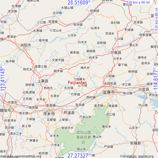
Feijiantan GPS coordinates[2]
27° 53' 47.256" North, 114° 6' 52.452" East
| Map corner | latitude | longitude |
|---|---|---|
| Upper-left | 28.51609°, | 113.41145° |
| Center: | 27.89646°, | 114.11457° |
| Lower-right: | 27.27327°, | 114.8177° |
| Map W x H: | 138.2×138.2 km | = 85.9×85.9mi |
| max Lat: | 53.31946° ⇑74.7% North |
| Feijiantan: | 27.89646° |
| min Lat: | ⇓25.3% South 18.22056° |
| min Long | Feijiantan | max Long |
| 75.07348° | 114.11457° | 134.28917° |
| W 49.4%⇐ | ⇒50.6% E |
Elevation
Elevation of Feijiantan is 146 m = 479 ft, and this is 338.8 m = 1112 ft below average elevation for this country.
| Max E: |
5622 m = 18445 ft | 52.6% |
| Avg. | 484.8 m = 1591 ft | |
| Feijiantan | 146 m = 479 ft | |
Min E: |
-3 m = -10 ft | 47.4% |
See also: China elevation on elevation.city.
Geographical zone
Feijiantan is located in North temperate zone (between Tropic of Cancer and the Arctic Circle). Distance of this Northern Tropic circle is 495.9 km =308.1 mi to South.| Distance of | km | miles | from Feijiantan |
|---|---|---|---|
| North Pole | 6905.3 | 4290.8 | to North |
| Arctic Circle | 4299.4 | 2671.5 | to North |
| Tropic Cancer | 495.9 | 308.1 | to South |
| Equator | 3101.8 | 1927.4 | to South |


Nearby cities:
15 places around Feijiantan: (largest is in red/bold)
• Cihua
15.5 km =9.6 mi,  326°
326°
• Fengdingshan
20.9 km =13 mi,  52°
52°
• Hongtang
17.1 km =10.6 mi,  86°
86°
• Jinrui
9.2 km =5.7 mi,  68°
68°
• Lingdong
22.5 km =14 mi,  33°
33°
• Nanmu
11.4 km =7.1 mi, 26°
• Raoshi
5.9 km =3.7 mi,  151°
151°
• Tiantai
11.9 km =7.4 mi,  231°
231°
• Tiantaishan
11.2 km =7 mi,  263°
263°
• Xicun
18.7 km =11.6 mi, 147°
• Xintian
16.2 km =10.1 mi,  119°
119°
• Xuanfeng
22.3 km =13.9 mi,  178°
178°
• Yinhe
21.9 km =13.6 mi, 179°
• Zhutan
17.9 km =11.1 mi,  14°
14°
• Zhuting
13.9 km =8.6 mi,  194°
194°
Sources, notices
• [Note1] Compared only with cities in China existing in our database
• [Src1] Map data: © OpenStreetMap contributors (CC-BY-SA)
• [Src2] Other city data from geonames.org with taken over terms of usage.
• [Src3] Geographical zone / Annual Mean Temperature by Robert A. Rohde @ Wikipedia
