Zhuanghe geodata
Zhuanghe (Liaoning) is a populated place; located in China in Asia/Shanghai (GMT+8) time zone. With population of 80,384 people, there are 528 cities with bigger population in this country. Compared to other cities in China, 85.3% of cities are located further ↓South; 92.7% of cities are located further ←West and 97.2% of cities have higher elevation than Zhuanghe. Note1


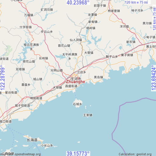
Zhuanghe GPS coordinates[2]
39° 42' 2.988" North, 122° 59' 27.996" East
| Map corner | latitude | longitude |
|---|---|---|
| Upper-left | 40.23968°, | 122.28799° |
| Center: | 39.70083°, | 122.99111° |
| Lower-right: | 39.15773°, | 123.69424° |
| Map W x H: | 120.3×120.3 km | = 74.8×74.8mi |
| max Lat: | 53.31946° ⇑14.7% North |
| Zhuanghe: | 39.70083° |
| min Lat: | ⇓85.3% South 18.22056° |
| min Long | Zhuanghe | max Long |
| 75.07348° | 122.99111° | 134.28917° |
| W 92.7%⇐ | ⇒7.3% E |
Elevation
Elevation of Zhuanghe is 5 m = 16 ft, and this is 479.8 m = 1574 ft below average elevation for this country.
| Max E: |
5622 m = 18445 ft | 97.2% |
| Avg. | 484.8 m = 1591 ft | |
| Zhuanghe | 5 m = 16 ft | |
Min E: |
-3 m = -10 ft | 2.8% |
See also: Zhuanghe elevation on elevation.city.
Geographical zone
Zhuanghe is located in North temperate zone (between Tropic of Cancer and the Arctic Circle). Distance of this Northern Tropic circle is 1808.4 km =1123.7 mi to South.| Distance of | km | miles | from Zhuanghe |
|---|---|---|---|
| North Pole | 5592.7 | 3475.1 | to North |
| Arctic Circle | 2986.9 | 1856 | to North |
| Tropic Cancer | 1808.4 | 1123.7 | to South |
| Equator | 4414.3 | 2742.9 | to South |


Nearby cities:
15 places around Zhuanghe: (largest is in red/bold)
• Buyunshan
43.3 km =26.9 mi,  325°
325°
• Dachang Shandao
58 km =36 mi,  215°
215°
• Kuangdonggou
58 km =36 mi,  335°
335°
• Linggou
64.4 km =40 mi,  35°
35°
• Qianying
53.4 km =33.2 mi,  17°
17°
• Qianyingzi
58.2 km =36.2 mi, 16°
• Shizijie
58.7 km =36.5 mi,  313°
313°
• Taipingzhuang
54.4 km =33.8 mi, 343°
• Taling
40.3 km =25 mi,  14°
14°
• Wanfu
61.7 km =38.3 mi,  322°
322°
• Xiangrong
50.1 km =31.1 mi, 12°
• Xindian
46.4 km =28.8 mi, 12°
• Yahe
63.5 km =39.5 mi, 22°
• Yanghe
53.4 km =33.2 mi, 41°
• Yangjiapu
61.9 km =38.5 mi,  27°
27°
Sources, notices
• [Note1] Compared only with cities in China existing in our database
• [Src1] Map data: © OpenStreetMap contributors (CC-BY-SA)
• [Src2] Other city data from geonames.org with taken over terms of usage.
• [Src3] Geographical zone / Annual Mean Temperature by Robert A. Rohde @ Wikipedia
