Taling geodata
Taling (Liaoning) is a seat of a fourth-order administrative division; located in China in Asia/Shanghai (GMT+8) time zone. In our database, there are 1268 cities with bigger population. Compared to other cities in China, 86.6% of cities are located further ↓South; 92.8% of cities are located further ←West and 61.5% of cities have higher elevation than Taling. Note1


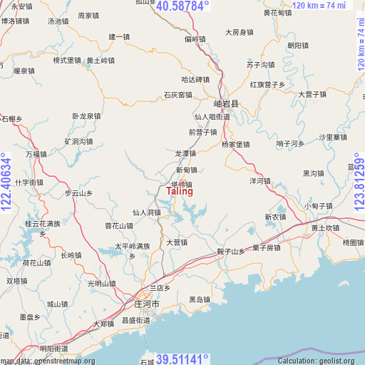
Taling GPS coordinates[2]
40° 3' 6.3" North, 123° 6' 34.056" East
| Map corner | latitude | longitude |
|---|---|---|
| Upper-left | 40.58784°, | 122.40634° |
| Center: | 40.05175°, | 123.10946° |
| Lower-right: | 39.51141°, | 123.81259° |
| Map W x H: | 119.7×119.7 km | = 74.4×74.4mi |
| max Lat: | 53.31946° ⇑13.4% North |
| Taling: | 40.05175° |
| min Lat: | ⇓86.6% South 18.22056° |
| min Long | Taling | max Long |
| 75.07348° | 123.10946° | 134.28917° |
| W 92.8%⇐ | ⇒7.2% E |
Elevation
Elevation of Taling is 90 m = 295 ft, and this is 394.8 m = 1295 ft below average elevation for this country.
| Max E: |
5622 m = 18445 ft | 61.5% |
| Avg. | 484.8 m = 1591 ft | |
| Taling | 90 m = 295 ft | |
Min E: |
-3 m = -10 ft | 38.5% |
See also: China elevation on elevation.city.
Geographical zone
Taling is located in North temperate zone (between Tropic of Cancer and the Arctic Circle). Distance of this Northern Tropic circle is 1847.4 km =1147.9 mi to South.| Distance of | km | miles | from Taling |
|---|---|---|---|
| North Pole | 5553.7 | 3450.9 | to North |
| Arctic Circle | 2947.8 | 1831.7 | to North |
| Tropic Cancer | 1847.4 | 1147.9 | to South |
| Equator | 4453.3 | 2767.2 | to South |


Nearby cities:
15 places around Taling: (largest is in red/bold)
• Buyunshan
34.6 km =21.5 mi,  264°
264°
• Hadabei
32.5 km =20.2 mi,  6°
6°
• Kuangdonggou
37 km =23 mi,  291°
291°
• Linggou
30.4 km =18.9 mi,  63°
63°
• Qianying
13.3 km =8.3 mi,  27°
27°
• Qianyingzi
18 km =11.2 mi,  20°
20°
• Shihuiyao
29 km =18 mi,  359°
359°
• Taipingzhuang
28.8 km =17.9 mi,  296°
296°
• Xiangrong
9.9 km =6.2 mi,  3°
3°
• Xindian
6.2 km =3.9 mi, 2°
• Xinglong
32 km =19.9 mi, 27°
• Xiuyan
30.2 km =18.8 mi, 27°
• Yahe
24.2 km =15 mi,  36°
36°
• Yanghe
25.5 km =15.8 mi,  88°
88°
• Yangjiapu
24.5 km =15.2 mi,  50°
50°
Sources, notices
• [Note1] Compared only with cities in China existing in our database
• [Src1] Map data: © OpenStreetMap contributors (CC-BY-SA)
• [Src2] Other city data from geonames.org with taken over terms of usage.
• [Src3] Geographical zone / Annual Mean Temperature by Robert A. Rohde @ Wikipedia
