Zhoutian geodata
Zhoutian (Jiangxi) is a seat of a fourth-order administrative division; located in China in Asia/Shanghai (GMT+8) time zone. In our database, there are 1268 cities with bigger population. Compared to other cities in China, 85% of cities are located further ↑North; 58.4% of cities are located further ←West and 55.6% of cities have lower elevation than Zhoutian. Note1


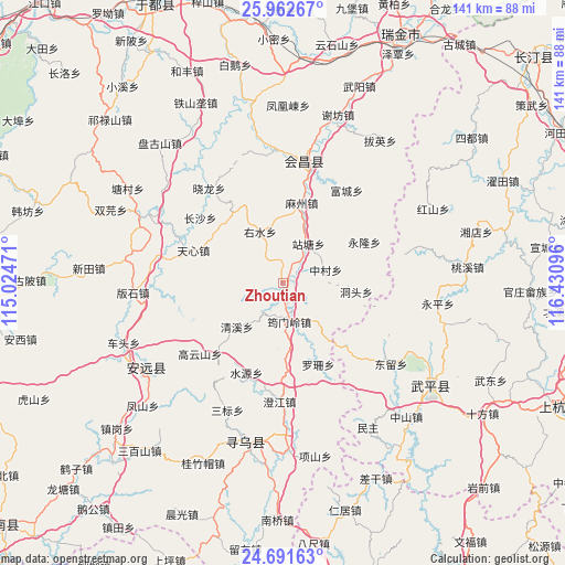
Zhoutian GPS coordinates[2]
25° 19' 43.752" North, 115° 43' 40.188" East
| Map corner | latitude | longitude |
|---|---|---|
| Upper-left | 25.96267°, | 115.02471° |
| Center: | 25.32882°, | 115.72783° |
| Lower-right: | 24.69163°, | 116.43096° |
| Map W x H: | 141.3×141.3 km | = 87.8×87.8mi |
| max Lat: | 53.31946° ⇑85% North |
| Zhoutian: | 25.32882° |
| min Lat: | ⇓15% South 18.22056° |
| min Long | Zhoutian | max Long |
| 75.07348° | 115.72783° | 134.28917° |
| W 58.4%⇐ | ⇒41.6% E |
Elevation
Elevation of Zhoutian is 212 m = 696 ft, and this is 272.8 m = 895 ft below average elevation for this country.
| Max E: |
5622 m = 18445 ft | 44.4% |
| Avg. | 484.8 m = 1591 ft | |
| Zhoutian | 212 m = 696 ft | |
Min E: |
-3 m = -10 ft | 55.6% |
See also: China elevation on elevation.city.
Geographical zone
Zhoutian is located in North temperate zone (between Tropic of Cancer and the Arctic Circle). Distance of this Northern Tropic circle is 210.4 km =130.7 mi to South.| Distance of | km | miles | from Zhoutian |
|---|---|---|---|
| North Pole | 7190.8 | 4468.2 | to North |
| Arctic Circle | 4584.9 | 2848.9 | to North |
| Tropic Cancer | 210.4 | 130.7 | to South |
| Equator | 2816.3 | 1750 | to South |


Nearby cities:
15 places around Zhoutian: (largest is in red/bold)
• Changling
11.8 km =7.3 mi,  141°
141°
• Changsha
26.2 km =16.3 mi,  308°
308°
• Dongtou
18.5 km =11.5 mi,  97°
97°
• Gaopai
21.5 km =13.4 mi,  326°
326°
• Gaoyunshan
27.3 km =17 mi,  229°
229°
• Luoshan
22.3 km =13.9 mi,  156°
156°
• Mazhou
20.5 km =12.7 mi,  13°
13°
• Qingxi
15.9 km =9.9 mi, 226°
• Shuiyuan
24.3 km =15.1 mi,  201°
201°
• Tianxin
23.7 km =14.7 mi,  288°
288°
• Yonglong
22.7 km =14.1 mi,  64°
64°
• Youshui
14 km =8.7 mi,  335°
335°
• Yunmenling
9.9 km =6.2 mi,  170°
170°
• Zhantang
11.7 km =7.3 mi,  33°
33°
• Zhongcun
11.2 km =7 mi,  73°
73°
Sources, notices
• [Note1] Compared only with cities in China existing in our database
• [Src1] Map data: © OpenStreetMap contributors (CC-BY-SA)
• [Src2] Other city data from geonames.org with taken over terms of usage.
• [Src3] Geographical zone / Annual Mean Temperature by Robert A. Rohde @ Wikipedia
