Dongtou geodata
Dongtou (Jiangxi) is a seat of a fourth-order administrative division; located in China in Asia/Shanghai (GMT+8) time zone. In our database, there are 1268 cities with bigger population. Compared to other cities in China, 85.1% of cities are located further ↑North; 59.5% of cities are located further ←West and 76.8% of cities have lower elevation than Dongtou. Note1


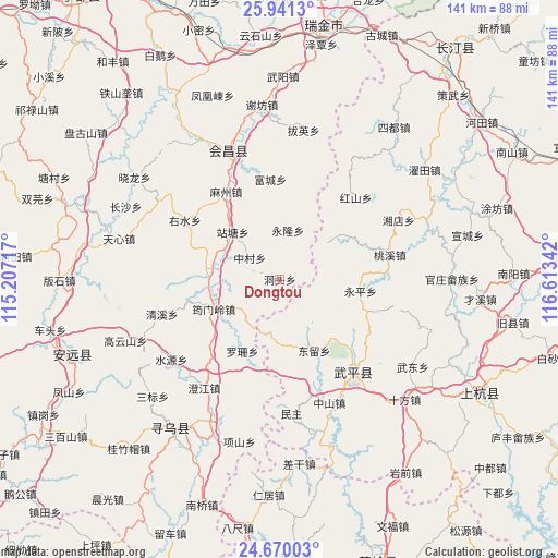
Dongtou GPS coordinates[2]
25° 18' 26.388" North, 115° 54' 37.044" East
| Map corner | latitude | longitude |
|---|---|---|
| Upper-left | 25.9413°, | 115.20717° |
| Center: | 25.30733°, | 115.91029° |
| Lower-right: | 24.67003°, | 116.61342° |
| Map W x H: | 141.4×141.4 km | = 87.9×87.9mi |
| max Lat: | 53.31946° ⇑85.1% North |
| Dongtou: | 25.30733° |
| min Lat: | ⇓14.9% South 18.22056° |
| min Long | Dongtou | max Long |
| 75.07348° | 115.91029° | 134.28917° |
| W 59.5%⇐ | ⇒40.5% E |
Elevation
Elevation of Dongtou is 572 m = 1877 ft, and this is 87.2 m = 286 ft above average elevation for this country.
| Max E: |
5622 m = 18445 ft | 23.2% |
| Dongtou | 572 m 1877 ft | |
| Avg. | 484.8 m = 1591 ft | |
Min E: |
-3 m = -10 ft | 76.8% |
See also: China elevation on elevation.city.
Geographical zone
Dongtou is located in North temperate zone (between Tropic of Cancer and the Arctic Circle). Distance of this Northern Tropic circle is 208 km =129.2 mi to South.| Distance of | km | miles | from Dongtou |
|---|---|---|---|
| North Pole | 7193.2 | 4469.6 | to North |
| Arctic Circle | 4587.3 | 2850.4 | to North |
| Tropic Cancer | 208 | 129.2 | to South |
| Equator | 2813.9 | 1748.5 | to South |


Nearby cities:
15 places around Dongtou: (largest is in red/bold)
• Changling
12.9 km =8 mi,  238°
238°
• Dahe
21.8 km =13.5 mi,  61°
61°
• Dongliu
19.8 km =12.3 mi,  156°
156°
• Fucheng
25.6 km =15.9 mi,  354°
354°
• Hongshan
28.4 km =17.6 mi,  42°
42°
• Luoshan
20.4 km =12.7 mi,  207°
207°
• Mazhou
26.1 km =16.2 mi,  328°
328°
• Taoxi
28.4 km =17.6 mi,  77°
77°
• Wan’an
26.5 km =16.5 mi,  136°
136°
• Yonglong
12.4 km =7.7 mi,  9°
9°
• Yongping
20.7 km =12.9 mi,  97°
97°
• Yunmenling
18.3 km =11.4 mi,  246°
246°
• Zhantang
16.9 km =10.5 mi,  315°
315°
• Zhongcun
9.4 km =5.8 mi,  306°
306°
• Zhoutian
18.5 km =11.5 mi,  277°
277°
Sources, notices
• [Note1] Compared only with cities in China existing in our database
• [Src1] Map data: © OpenStreetMap contributors (CC-BY-SA)
• [Src2] Other city data from geonames.org with taken over terms of usage.
• [Src3] Geographical zone / Annual Mean Temperature by Robert A. Rohde @ Wikipedia
