Longhu geodata
Longhu (Fujian) is a populated place; located in China in Asia/Shanghai (GMT+8) time zone. With population of 850 people, there are 1206 cities with bigger population in this country. Compared to other cities in China, 87.8% of cities are located further ↑North; 73.9% of cities are located further ←West and 92.7% of cities have higher elevation than Longhu. Note1


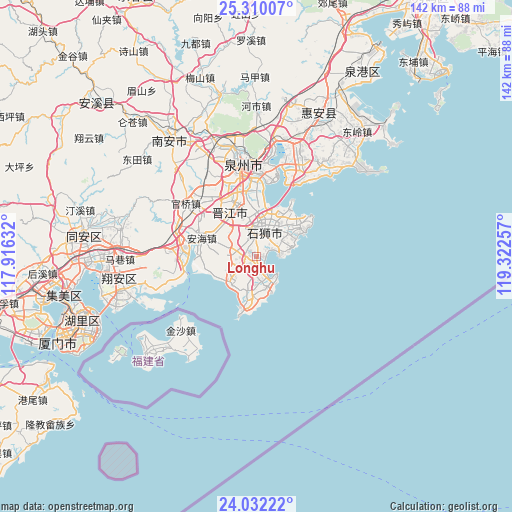
Longhu GPS coordinates[2]
24° 40' 22.008" North, 118° 37' 9.984" East
| Map corner | latitude | longitude |
|---|---|---|
| Upper-left | 25.31007°, | 117.91632° |
| Center: | 24.67278°, | 118.61944° |
| Lower-right: | 24.03222°, | 119.32257° |
| Map W x H: | 142.1×142.1 km | = 88.3×88.3mi |
| max Lat: | 53.31946° ⇑87.8% North |
| Longhu: | 24.67278° |
| min Lat: | ⇓12.2% South 18.22056° |
| min Long | Longhu | max Long |
| 75.07348° | 118.61944° | 134.28917° |
| W 73.9%⇐ | ⇒26.1% E |
Elevation
Elevation of Longhu is 8 m = 26 ft, and this is 476.8 m = 1564 ft below average elevation for this country.
| Max E: |
5622 m = 18445 ft | 92.7% |
| Avg. | 484.8 m = 1591 ft | |
| Longhu | 8 m = 26 ft | |
Min E: |
-3 m = -10 ft | 7.3% |
See also: China elevation on elevation.city.
Geographical zone
Longhu is located in North temperate zone (between Tropic of Cancer and the Arctic Circle). Distance of this Northern Tropic circle is 137.4 km =85.4 mi to South.| Distance of | km | miles | from Longhu |
|---|---|---|---|
| North Pole | 7263.7 | 4513.5 | to North |
| Arctic Circle | 4657.8 | 2894.2 | to North |
| Tropic Cancer | 137.4 | 85.4 | to South |
| Equator | 2743.4 | 1704.7 | to South |


Nearby cities:
15 places around Longhu: (largest is in red/bold)
• Anhai
15.9 km =9.9 mi,  289°
289°
• Chendai
16.7 km =10.4 mi,  353°
353°
• Dongshi
16.5 km =10.3 mi,  267°
267°
• Jinjiang
17 km =10.6 mi,  344°
344°
• Jinjing
11.1 km =6.9 mi,  191°
191°
• Kerencun
10.9 km =6.8 mi,  157°
157°
• Maping
6.9 km =4.3 mi,  283°
283°
• Neikeng
20.4 km =12.7 mi,  307°
307°
• Shishi
7.6 km =4.7 mi,  7°
7°
• Tatou
11.2 km =7 mi,  236°
236°
• Wubao
10.8 km =6.7 mi,  217°
217°
• Xibin
14 km =8.7 mi,  0°
0°
• Yakou
1.8 km =1.1 mi,  92°
92°
• Yinglin
6 km =3.7 mi, 221°
• Yongning
7.2 km =4.5 mi,  83°
83°
Sources, notices
• [Note1] Compared only with cities in China existing in our database
• [Src1] Map data: © OpenStreetMap contributors (CC-BY-SA)
• [Src2] Other city data from geonames.org with taken over terms of usage.
• [Src3] Geographical zone / Annual Mean Temperature by Robert A. Rohde @ Wikipedia
