Kerencun geodata
Kerencun (Fujian) is a populated place; located in China in Asia/Shanghai (GMT+8) time zone. With population of 4,810 people, there are 875 cities with bigger population in this country. Compared to other cities in China, 88.2% of cities are located further ↑North; 74.2% of cities are located further ←West and 99.7% of cities have higher elevation than Kerencun. Note1


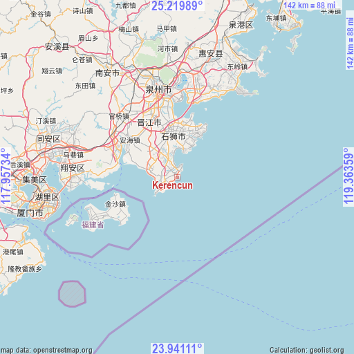
Kerencun GPS coordinates[2]
24° 34' 55.668" North, 118° 39' 37.656" East
| Map corner | latitude | longitude |
|---|---|---|
| Upper-left | 25.21989°, | 117.95734° |
| Center: | 24.58213°, | 118.66046° |
| Lower-right: | 23.94111°, | 119.36359° |
| Map W x H: | 142.2×142.2 km | = 88.4×88.4mi |
| max Lat: | 53.31946° ⇑88.2% North |
| Kerencun: | 24.58213° |
| min Lat: | ⇓11.8% South 18.22056° |
| min Long | Kerencun | max Long |
| 75.07348° | 118.66046° | 134.28917° |
| W 74.2%⇐ | ⇒25.8% E |
Elevation
Elevation of Kerencun is 1 m = 3 ft, and this is 483.8 m = 1587 ft below average elevation for this country.
| Max E: |
5622 m = 18445 ft | 99.7% |
| Avg. | 484.8 m = 1591 ft | |
| Kerencun | 1 m = 3 ft | |
Min E: |
-3 m = -10 ft | 0.3% |
See also: China elevation on elevation.city.
Geographical zone
Kerencun is located in North temperate zone (between Tropic of Cancer and the Arctic Circle). Distance of this Northern Tropic circle is 127.4 km =79.2 mi to South.| Distance of | km | miles | from Kerencun |
|---|---|---|---|
| North Pole | 7273.8 | 4519.7 | to North |
| Arctic Circle | 4667.9 | 2900.5 | to North |
| Tropic Cancer | 127.4 | 79.2 | to South |
| Equator | 2733.3 | 1698.4 | to South |


Nearby cities:
15 places around Kerencun: (largest is in red/bold)
• Anhai
24.5 km =15.2 mi,  308°
308°
• Chendai
27.4 km =17 mi,  347°
347°
• Dongshi
22.6 km =14 mi,  294°
294°
• Jinjiang
27.8 km =17.3 mi,  341°
341°
• Jinjing
6.4 km =4 mi,  262°
262°
• Longhu
10.9 km =6.8 mi, 337°
• Maping
16 km =9.9 mi,  317°
317°
• Shijing
24.2 km =15 mi,  279°
279°
• Shishi
17.9 km =11.1 mi, 349°
• Tatou
14.1 km =8.8 mi, 286°
• Wubao
10.9 km =6.8 mi, 278°
• Xibin
24.4 km =15.2 mi, 350°
• Yakou
10.3 km =6.4 mi, 346°
• Yinglin
9.8 km =6.1 mi,  304°
304°
• Yongning
11.3 km =7 mi,  15°
15°
Sources, notices
• [Note1] Compared only with cities in China existing in our database
• [Src1] Map data: © OpenStreetMap contributors (CC-BY-SA)
• [Src2] Other city data from geonames.org with taken over terms of usage.
• [Src3] Geographical zone / Annual Mean Temperature by Robert A. Rohde @ Wikipedia
