Yongning geodata
Yongning (Fujian) is a populated place; located in China in Asia/Shanghai (GMT+8) time zone. With population of 8,460 people, there are 823 cities with bigger population in this country. Compared to other cities in China, 87.7% of cities are located further ↑North; 74.4% of cities are located further ←West and 82.4% of cities have higher elevation than Yongning. Note1


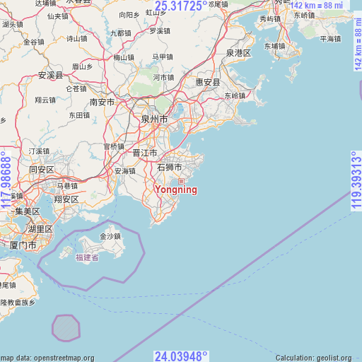
Yongning GPS coordinates[2]
24° 40' 48" North, 118° 41' 24" East
| Map corner | latitude | longitude |
|---|---|---|
| Upper-left | 25.31725°, | 117.98688° |
| Center: | 24.68°, | 118.69° |
| Lower-right: | 24.03948°, | 119.39313° |
| Map W x H: | 142.1×142.1 km | = 88.3×88.3mi |
| max Lat: | 53.31946° ⇑87.7% North |
| Yongning: | 24.68° |
| min Lat: | ⇓12.3% South 18.22056° |
| min Long | Yongning | max Long |
| 75.07348° | 118.69° | 134.28917° |
| W 74.4%⇐ | ⇒25.6% E |
Elevation
Elevation of Yongning is 21 m = 69 ft, and this is 463.8 m = 1522 ft below average elevation for this country.
| Max E: |
5622 m = 18445 ft | 82.4% |
| Avg. | 484.8 m = 1591 ft | |
| Yongning | 21 m = 69 ft | |
Min E: |
-3 m = -10 ft | 17.6% |
See also: China elevation on elevation.city.
Geographical zone
Yongning is located in North temperate zone (between Tropic of Cancer and the Arctic Circle). Distance of this Northern Tropic circle is 138.2 km =85.9 mi to South.| Distance of | km | miles | from Yongning |
|---|---|---|---|
| North Pole | 7262.9 | 4513 | to North |
| Arctic Circle | 4657 | 2893.7 | to North |
| Tropic Cancer | 138.2 | 85.9 | to South |
| Equator | 2744.2 | 1705.2 | to South |


Nearby cities:
15 places around Yongning: (largest is in red/bold)
• Anhai
22.6 km =14 mi,  281°
281°
• Baiqi
22.6 km =14 mi,  4°
4°
• Chendai
18.2 km =11.3 mi,  330°
330°
• Chidian
23.3 km =14.5 mi, 329°
• Jinjiang
19.5 km =12.1 mi,  323°
323°
• Jinjing
15 km =9.3 mi,  218°
218°
• Kerencun
11.3 km =7 mi,  195°
195°
• Longhu
7.2 km =4.5 mi,  263°
263°
• Maping
13.9 km =8.6 mi,  273°
273°
• Shishi
9.1 km =5.7 mi, 317°
• Tatou
17.9 km =11.1 mi,  247°
247°
• Wubao
16.7 km =10.4 mi,  235°
235°
• Xibin
15 km =9.3 mi, 331°
• Yakou
5.4 km =3.4 mi, 260°
• Yinglin
12.3 km =7.6 mi, 244°
Sources, notices
• [Note1] Compared only with cities in China existing in our database
• [Src1] Map data: © OpenStreetMap contributors (CC-BY-SA)
• [Src2] Other city data from geonames.org with taken over terms of usage.
• [Src3] Geographical zone / Annual Mean Temperature by Robert A. Rohde @ Wikipedia
