Chendai geodata
Chendai (Fujian) is a seat of a fourth-order administrative division; located in China in Asia/Shanghai (GMT+8) time zone. In our database, there are 1268 cities with bigger population. Compared to other cities in China, 87.1% of cities are located further ↑North; 73.8% of cities are located further ←West and 88.7% of cities have higher elevation than Chendai. Note1


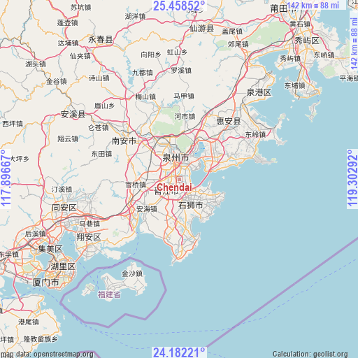
Chendai GPS coordinates[2]
24° 49' 19.236" North, 118° 35' 59.244" East
| Map corner | latitude | longitude |
|---|---|---|
| Upper-left | 25.45852°, | 117.89667° |
| Center: | 24.82201°, | 118.59979° |
| Lower-right: | 24.18221°, | 119.30292° |
| Map W x H: | 141.9×141.9 km | = 88.2×88.2mi |
| max Lat: | 53.31946° ⇑87.1% North |
| Chendai: | 24.82201° |
| min Lat: | ⇓12.9% South 18.22056° |
| min Long | Chendai | max Long |
| 75.07348° | 118.59979° | 134.28917° |
| W 73.8%⇐ | ⇒26.2% E |
Elevation
Elevation of Chendai is 11 m = 36 ft, and this is 473.8 m = 1554 ft below average elevation for this country.
| Max E: |
5622 m = 18445 ft | 88.7% |
| Avg. | 484.8 m = 1591 ft | |
| Chendai | 11 m = 36 ft | |
Min E: |
-3 m = -10 ft | 11.3% |
See also: China elevation on elevation.city.
Geographical zone
Chendai is located in North temperate zone (between Tropic of Cancer and the Arctic Circle). Distance of this Northern Tropic circle is 154 km =95.7 mi to South.| Distance of | km | miles | from Chendai |
|---|---|---|---|
| North Pole | 7247.1 | 4503.1 | to North |
| Arctic Circle | 4641.2 | 2883.9 | to North |
| Tropic Cancer | 154 | 95.7 | to South |
| Equator | 2759.9 | 1714.9 | to South |


Nearby cities:
15 places around Chendai: (largest is in red/bold)
• Anhai
17.3 km =10.7 mi,  228°
228°
• Baiqi
12.9 km =8 mi,  58°
58°
• Chidian
5.1 km =3.2 mi,  328°
328°
• Cizao
11.3 km =7 mi,  269°
269°
• Fashi
6.9 km =4.3 mi,  16°
16°
• Fengzhou
16.5 km =10.3 mi,  336°
336°
• Jinjiang
2.6 km =1.6 mi,  264°
264°
• Longhu
16.7 km =10.4 mi,  173°
173°
• Luoyang
17.4 km =10.8 mi,  28°
28°
• Maping
15.7 km =9.8 mi,  197°
197°
• Neikeng
14.6 km =9.1 mi,  253°
253°
• Quanzhou
10.3 km =6.4 mi,  352°
352°
• Shishi
9.5 km =5.9 mi,  161°
161°
• Xibin
3.3 km =2.1 mi,  141°
141°
• Yakou
17.1 km =10.6 mi, 167°
Sources, notices
• [Note1] Compared only with cities in China existing in our database
• [Src1] Map data: © OpenStreetMap contributors (CC-BY-SA)
• [Src2] Other city data from geonames.org with taken over terms of usage.
• [Src3] Geographical zone / Annual Mean Temperature by Robert A. Rohde @ Wikipedia
