Zhetang geodata
Zhetang (Jiangsu) is a seat of a fourth-order administrative division; located in China in Asia/Shanghai (GMT+8) time zone. In our database, there are 1268 cities with bigger population. Compared to other cities in China, 59.9% of cities are located further ↓South; 75.6% of cities are located further ←West and 83.9% of cities have higher elevation than Zhetang. Note1


Zhetang GPS coordinates[2]
31° 45' 22.104" North, 118° 54' 55.872" East
| Map corner | latitude | longitude |
|---|---|---|
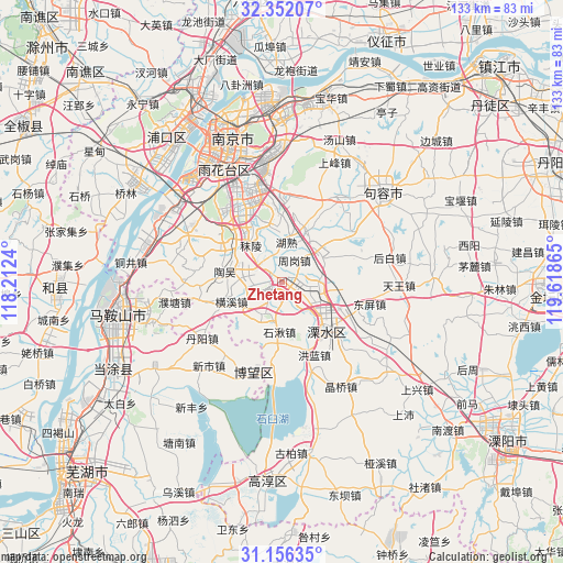
| Upper-left | 32.35207°, | 118.2124° |
| Center: | 31.75614°, | 118.91552° |
| Lower-right: | 31.15635°, | 119.61865° |
| Map W x H: | 133×133 km | = 82.6×82.6mi |
| max Lat: | 53.31946° ⇑40.1% North |
| Zhetang: | 31.75614° |
| min Lat: | ⇓59.9% South 18.22056° |
| min Long | Zhetang | max Long |
| 75.07348° | 118.91552° | 134.28917° |
| W 75.6%⇐ | ⇒24.4% E |
Elevation
Elevation of Zhetang is 18 m = 59 ft, and this is 466.8 m = 1531 ft below average elevation for this country.
| Max E: |
5622 m = 18445 ft | 83.9% |
| Avg. | 484.8 m = 1591 ft | |
| Zhetang | 18 m = 59 ft | |
Min E: |
-3 m = -10 ft | 16.1% |
See also: China elevation on elevation.city.
Geographical zone
Zhetang is located in North temperate zone (between Tropic of Cancer and the Arctic Circle). Distance of this Northern Tropic circle is 925 km =574.8 mi to South.| Distance of | km | miles | from Zhetang |
|---|---|---|---|
| North Pole | 6476.1 | 4024.1 | to North |
| Arctic Circle | 3870.2 | 2404.8 | to North |
| Tropic Cancer | 925 | 574.8 | to South |
| Equator | 3531 | 2194.1 | to South |


Nearby cities:
15 places around Zhetang: (largest is in red/bold)
• Bowang
22.7 km =14.1 mi,  198°
198°
• Danyang
22.4 km =13.9 mi,  237°
237°
• Danyang
23.6 km =14.7 mi,  233°
233°
• Dongshan
23.5 km =14.6 mi,  340°
340°
• Hengxi
14.7 km =9.1 mi,  252°
252°
• Honglan
17.6 km =10.9 mi,  159°
159°
• Houbai
25.5 km =15.8 mi,  76°
76°
• Lukou
4.8 km =3 mi,  290°
290°
• Putang
25.6 km =15.9 mi,  259°
259°
• Shiqiu
11.9 km =7.4 mi,  183°
183°
• Shuiyang
15.4 km =9.6 mi,  133°
133°
• Taowu
13.8 km =8.6 mi,  279°
279°
• Tuqiao
24.5 km =15.2 mi,  33°
33°
• Yongyang
15.2 km =9.4 mi,  135°
135°
• Zhougang
6.2 km =3.9 mi,  43°
43°
Sources, notices
• [Note1] Compared only with cities in China existing in our database
• [Src1] Map data: © OpenStreetMap contributors (CC-BY-SA)
• [Src2] Other city data from geonames.org with taken over terms of usage.
• [Src3] Geographical zone / Annual Mean Temperature by Robert A. Rohde @ Wikipedia
