Danyang geodata
Danyang (Jiangsu) is a seat of a fourth-order administrative division; located in China in Asia/Shanghai (GMT+8) time zone. In our database, there are 1268 cities with bigger population. Compared to other cities in China, 59.1% of cities are located further ↓South; 74.5% of cities are located further ←West and 86.2% of cities have higher elevation than Danyang. Note1


Danyang GPS coordinates[2]
31° 37' 45.192" North, 118° 42' 56.34" East
| Map corner | latitude | longitude |
|---|---|---|
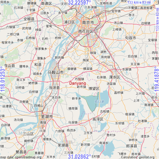
| Upper-left | 32.22597°, | 118.01253° |
| Center: | 31.62922°, | 118.71565° |
| Lower-right: | 31.02862°, | 119.41878° |
| Map W x H: | 133.1×133.1 km | = 82.7×82.7mi |
| max Lat: | 53.31946° ⇑40.9% North |
| Danyang: | 31.62922° |
| min Lat: | ⇓59.1% South 18.22056° |
| min Long | Danyang | max Long |
| 75.07348° | 118.71565° | 134.28917° |
| W 74.5%⇐ | ⇒25.5% E |
Elevation
Elevation of Danyang is 14 m = 46 ft, and this is 470.8 m = 1545 ft below average elevation for this country.
| Max E: |
5622 m = 18445 ft | 86.2% |
| Avg. | 484.8 m = 1591 ft | |
| Danyang | 14 m = 46 ft | |
Min E: |
-3 m = -10 ft | 13.8% |
See also: China elevation on elevation.city.
Geographical zone
Danyang is located in North temperate zone (between Tropic of Cancer and the Arctic Circle). Distance of this Northern Tropic circle is 910.9 km =566 mi to South.| Distance of | km | miles | from Danyang |
|---|---|---|---|
| North Pole | 6490.2 | 4032.8 | to North |
| Arctic Circle | 3884.3 | 2413.6 | to North |
| Tropic Cancer | 910.9 | 566 | to South |
| Equator | 3516.8 | 2185.2 | to South |


Nearby cities:
15 places around Danyang: (largest is in red/bold)
• Bowang
13.7 km =8.5 mi,  122°
122°
• Danyang
2.1 km =1.3 mi,  358°
358°
• Hengxi
10.9 km =6.8 mi,  26°
26°
• Huhe
17.8 km =11.1 mi,  222°
222°
• Huoli
15 km =9.3 mi,  298°
298°
• Liu‘an
18.4 km =11.4 mi,  278°
278°
• Ma’anshan
20.4 km =12.7 mi,  287°
287°
• Putang
11.2 km =7 mi,  325°
325°
• Shiqiu
18.4 km =11.4 mi,  83°
83°
• Taowu
17.3 km =10.7 mi,  17°
17°
• Xiangshan
12.7 km =7.9 mi, 285°
• Xinfeng
15.7 km =9.8 mi,  189°
189°
• Xinshi
5.9 km =3.7 mi,  164°
164°
• Xuejin
9.1 km =5.7 mi,  229°
229°
• Yintang
17.9 km =11.1 mi,  260°
260°
Sources, notices
• [Note1] Compared only with cities in China existing in our database
• [Src1] Map data: © OpenStreetMap contributors (CC-BY-SA)
• [Src2] Other city data from geonames.org with taken over terms of usage.
• [Src3] Geographical zone / Annual Mean Temperature by Robert A. Rohde @ Wikipedia
