Lukou geodata
Lukou (Jiangsu) is a seat of a fourth-order administrative division; located in China in Asia/Shanghai (GMT+8) time zone. In our database, there are 1268 cities with bigger population. Compared to other cities in China, 60% of cities are located further ↓South; 75.4% of cities are located further ←West and 88.7% of cities have higher elevation than Lukou. Note1


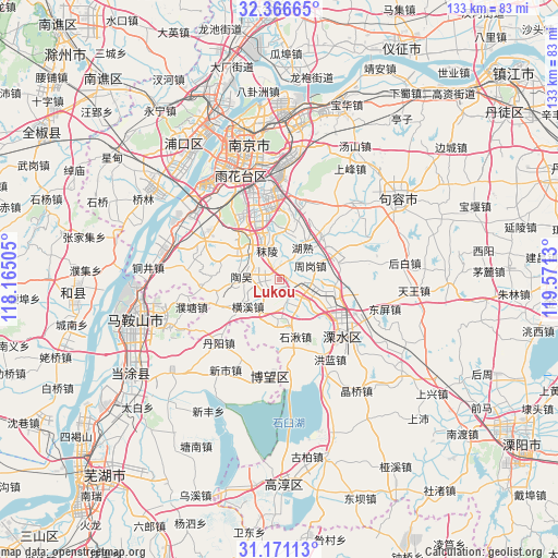
Lukou GPS coordinates[2]
31° 46' 14.952" North, 118° 52' 5.412" East
| Map corner | latitude | longitude |
|---|---|---|
| Upper-left | 32.36665°, | 118.16505° |
| Center: | 31.77082°, | 118.86817° |
| Lower-right: | 31.17113°, | 119.5713° |
| Map W x H: | 132.9×132.9 km | = 82.6×82.6mi |
| max Lat: | 53.31946° ⇑40% North |
| Lukou: | 31.77082° |
| min Lat: | ⇓60% South 18.22056° |
| min Long | Lukou | max Long |
| 75.07348° | 118.86817° | 134.28917° |
| W 75.4%⇐ | ⇒24.6% E |
Elevation
Elevation of Lukou is 11 m = 36 ft, and this is 473.8 m = 1554 ft below average elevation for this country.
| Max E: |
5622 m = 18445 ft | 88.7% |
| Avg. | 484.8 m = 1591 ft | |
| Lukou | 11 m = 36 ft | |
Min E: |
-3 m = -10 ft | 11.3% |
See also: China elevation on elevation.city.
Geographical zone
Lukou is located in North temperate zone (between Tropic of Cancer and the Arctic Circle). Distance of this Northern Tropic circle is 926.7 km =575.8 mi to South.| Distance of | km | miles | from Lukou |
|---|---|---|---|
| North Pole | 6474.5 | 4023.1 | to North |
| Arctic Circle | 3868.6 | 2403.8 | to North |
| Tropic Cancer | 926.7 | 575.8 | to South |
| Equator | 3532.6 | 2195.1 | to South |


Nearby cities:
15 places around Lukou: (largest is in red/bold)
• Bowang
23.2 km =14.4 mi,  187°
187°
• Danyang
19.9 km =12.4 mi,  226°
226°
• Danyang
21.4 km =13.3 mi,  222°
222°
• Dongshan
20.8 km =12.9 mi,  350°
350°
• Guli
21.5 km =13.4 mi,  305°
305°
• Hengxi
11.3 km =7 mi,  237°
237°
• Honglan
21 km =13 mi,  149°
149°
• Putang
21.7 km =13.5 mi,  252°
252°
• Shiqiu
14 km =8.7 mi,  164°
164°
• Shuiyang
19.9 km =12.4 mi,  127°
127°
• Taowu
9.2 km =5.7 mi,  274°
274°
• Xinshi
25 km =15.5 mi,  210°
210°
• Yongyang
19.6 km =12.2 mi, 129°
• Zhetang
4.8 km =3 mi,  110°
110°
• Zhougang
9.2 km =5.7 mi,  71°
71°
Sources, notices
• [Note1] Compared only with cities in China existing in our database
• [Src1] Map data: © OpenStreetMap contributors (CC-BY-SA)
• [Src2] Other city data from geonames.org with taken over terms of usage.
• [Src3] Geographical zone / Annual Mean Temperature by Robert A. Rohde @ Wikipedia
