Xincheng geodata
Xincheng (Jiangsu) is a seat of a fourth-order administrative division; located in China in Asia/Shanghai (GMT+8) time zone. In our database, there are 1268 cities with bigger population. Compared to other cities in China, 62.9% of cities are located further ↓South; 77.2% of cities are located further ←West and 89.9% of cities have higher elevation than Xincheng. Note1


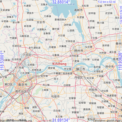
Xincheng GPS coordinates[2]
32° 17' 15.684" North, 119° 13' 59.268" East
| Map corner | latitude | longitude |
|---|---|---|
| Upper-left | 32.88014°, | 118.53001° |
| Center: | 32.28769°, | 119.23313° |
| Lower-right: | 31.69134°, | 119.93626° |
| Map W x H: | 132.2×132.2 km | = 82.1×82.1mi |
| max Lat: | 53.31946° ⇑37.1% North |
| Xincheng: | 32.28769° |
| min Lat: | ⇓62.9% South 18.22056° |
| min Long | Xincheng | max Long |
| 75.07348° | 119.23313° | 134.28917° |
| W 77.2%⇐ | ⇒22.8% E |
Elevation
Elevation of Xincheng is 10 m = 33 ft, and this is 474.8 m = 1558 ft below average elevation for this country.
| Max E: |
5622 m = 18445 ft | 89.9% |
| Avg. | 484.8 m = 1591 ft | |
| Xincheng | 10 m = 33 ft | |
Min E: |
-3 m = -10 ft | 10.1% |
See also: China elevation on elevation.city.
Geographical zone
Xincheng is located in North temperate zone (between Tropic of Cancer and the Arctic Circle). Distance of this Northern Tropic circle is 984.1 km =611.5 mi to South.| Distance of | km | miles | from Xincheng |
|---|---|---|---|
| North Pole | 6417 | 3987.3 | to North |
| Arctic Circle | 3811.1 | 2368.1 | to North |
| Tropic Cancer | 984.1 | 611.5 | to South |
| Equator | 3590.1 | 2230.8 | to South |


Nearby cities:
15 places around Xincheng: (largest is in red/bold)
• Bali
15.6 km =9.7 mi,  88°
88°
• Chahe
15.1 km =9.4 mi,  67°
67°
• Gaozi
14.7 km =9.1 mi,  153°
153°
• Guazhou
14.6 km =9.1 mi,  105°
105°
• Jiangwang
15.4 km =9.6 mi,  56°
56°
• Jing’an
10.7 km =6.6 mi,  232°
232°
• Liuji
16.4 km =10.2 mi,  5°
5°
• Maji
9.7 km =6 mi,  320°
320°
• Poxi
7.7 km =4.8 mi,  83°
83°
• Qingshan
15.5 km =9.6 mi,  255°
255°
• Shiye
10.6 km =6.6 mi,  141°
141°
• Xiashu
13.5 km =8.4 mi,  199°
199°
• Xinji
7.2 km =4.5 mi,  51°
51°
• Yangmiao
16.9 km =10.5 mi,  32°
32°
• Zhenzhou
6 km =3.7 mi, 262°
Sources, notices
• [Note1] Compared only with cities in China existing in our database
• [Src1] Map data: © OpenStreetMap contributors (CC-BY-SA)
• [Src2] Other city data from geonames.org with taken over terms of usage.
• [Src3] Geographical zone / Annual Mean Temperature by Robert A. Rohde @ Wikipedia
