Qingping geodata
Qingping (Henan) is a seat of a third-order administrative division; located in China in Asia/Shanghai (GMT+8) time zone. In our database, there are 1268 cities with bigger population. Compared to other cities in China, 72.9% of cities are located further ↓South; 55.1% of cities are located further →East and 63.6% of cities have lower elevation than Qingping. Note1


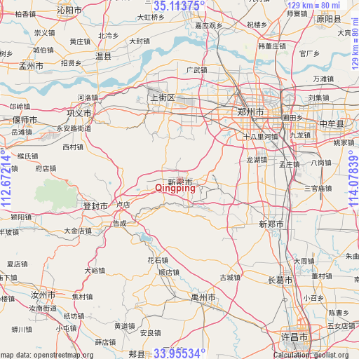
Qingping GPS coordinates[2]
34° 32' 11.616" North, 113° 22' 30.936" East
| Map corner | latitude | longitude |
|---|---|---|
| Upper-left | 35.11375°, | 112.67214° |
| Center: | 34.53656°, | 113.37526° |
| Lower-right: | 33.95534°, | 114.07839° |
| Map W x H: | 128.8×128.8 km | = 80×80mi |
| max Lat: | 53.31946° ⇑27.1% North |
| Qingping: | 34.53656° |
| min Lat: | ⇓72.9% South 18.22056° |
| min Long | Qingping | max Long |
| 75.07348° | 113.37526° | 134.28917° |
| W 44.9%⇐ | ⇒55.1% E |
Elevation
Elevation of Qingping is 305 m = 1001 ft, and this is 179.8 m = 590 ft below average elevation for this country.
| Max E: |
5622 m = 18445 ft | 36.4% |
| Avg. | 484.8 m = 1591 ft | |
| Qingping | 305 m = 1001 ft | |
Min E: |
-3 m = -10 ft | 63.6% |
See also: China elevation on elevation.city.
Geographical zone
Qingping is located in North temperate zone (between Tropic of Cancer and the Arctic Circle). Distance of this Northern Tropic circle is 1234.2 km =766.9 mi to South.| Distance of | km | miles | from Qingping |
|---|---|---|---|
| North Pole | 6167 | 3832 | to North |
| Arctic Circle | 3561.1 | 2212.8 | to North |
| Tropic Cancer | 1234.2 | 766.9 | to South |
| Equator | 3840.1 | 2386.1 | to South |


Nearby cities:
15 places around Qingping: (largest is in red/bold)
• Anliang
55.6 km =34.5 mi,  190°
190°
• Huaihelu
31.5 km =19.6 mi,  50°
50°
• Huangdao
55.8 km =34.7 mi,  200°
200°
• Jianshe
50.6 km =31.4 mi,  134°
134°
• Jianshelu
32 km =19.9 mi,  41°
41°
• Jiyuanlu
33.3 km =20.7 mi,  342°
342°
• Songyang
33.1 km =20.6 mi,  254°
254°
• Suohe
27.9 km =17.3 mi,  356°
356°
• Wenquan
52.2 km =32.4 mi,  328°
328°
• Xinhualu
35.6 km =22.1 mi,  115°
115°
• Yanshi Chengguanzhen
56.7 km =35.2 mi,  290°
290°
• Yingchuan
42.3 km =26.3 mi,  168°
168°
• Zhengzhou
35.1 km =21.8 mi, 45°
• Zhongmu Chengguanzhen
57.4 km =35.7 mi,  70°
70°
• Zijinglu
44.5 km =27.7 mi,  303°
303°
Sources, notices
• [Note1] Compared only with cities in China existing in our database
• [Src1] Map data: © OpenStreetMap contributors (CC-BY-SA)
• [Src2] Other city data from geonames.org with taken over terms of usage.
• [Src3] Geographical zone / Annual Mean Temperature by Robert A. Rohde @ Wikipedia
