Wenping geodata
Wenping (Yunnan) is a seat of a third-order administrative division; located in China in Asia/Shanghai (GMT+8) time zone. In our database, there are 1268 cities with bigger population. Compared to other cities in China, 77.8% of cities are located further ↑North; 90.9% of cities are located further →East and 94.7% of cities have lower elevation than Wenping. Note1


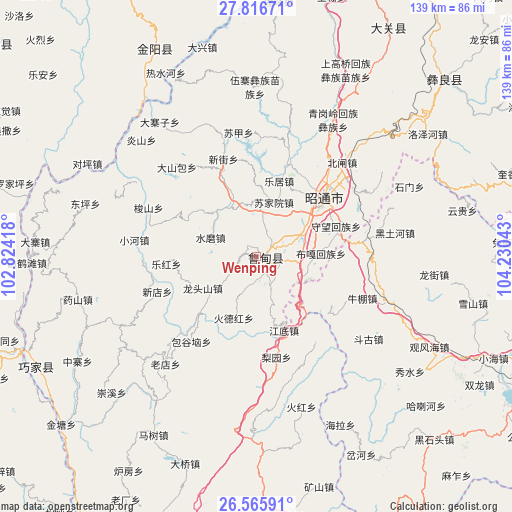
Wenping GPS coordinates[2]
27° 11' 35.016" North, 103° 31' 38.28" East
| Map corner | latitude | longitude |
|---|---|---|
| Upper-left | 27.81671°, | 102.82418° |
| Center: | 27.19306°, | 103.5273° |
| Lower-right: | 26.56591°, | 104.23043° |
| Map W x H: | 139.1×139.1 km | = 86.4×86.4mi |
| max Lat: | 53.31946° ⇑77.8% North |
| Wenping: | 27.19306° |
| min Lat: | ⇓22.2% South 18.22056° |
| min Long | Wenping | max Long |
| 75.07348° | 103.5273° | 134.28917° |
| W 9.1%⇐ | ⇒90.9% E |
Elevation
Elevation of Wenping is 2018 m = 6621 ft, and this is 1533.2 m = 5030 ft above average elevation for this country.
| Max E: |
5622 m = 18445 ft | 5.3% |
| Wenping | 2018 m 6621 ft | |
| Avg. | 484.8 m = 1591 ft | |
Min E: |
-3 m = -10 ft | 94.7% |
See also: China elevation on elevation.city.
Geographical zone
Wenping is located in North temperate zone (between Tropic of Cancer and the Arctic Circle). Distance of this Northern Tropic circle is 417.7 km =259.5 mi to South.| Distance of | km | miles | from Wenping |
|---|---|---|---|
| North Pole | 6983.5 | 4339.3 | to North |
| Arctic Circle | 4377.6 | 2720.1 | to North |
| Tropic Cancer | 417.7 | 259.5 | to South |
| Equator | 3023.6 | 1878.8 | to South |


Nearby cities:
15 places around Wenping: (largest is in red/bold)
• Daliyuan
4.2 km =2.6 mi,  255°
255°
• Guji
24.2 km =15 mi, 263°
• Jiecun
56.8 km =35.3 mi,  288°
288°
• Laodianzi
37.3 km =23.2 mi,  218°
218°
• Laojiezi
53.2 km =33.1 mi,  226°
226°
• Pengjia Zhaizi
46.2 km =28.7 mi,  359°
359°
• Sanguanzhai
28.4 km =17.6 mi,  250°
250°
• Shanjiao
47.6 km =29.6 mi, 287°
• Shuigou
56 km =34.8 mi,  239°
239°
• Shuigou’ao
19.1 km =11.9 mi, 244°
• Tiandiba
62.9 km =39.1 mi,  334°
334°
• Wanhechang
64.8 km =40.3 mi, 358°
• Xiangyang
55.3 km =34.4 mi,  209°
209°
• Xincun
63.1 km =39.2 mi,  32°
32°
• Zhaotong
23.2 km =14.4 mi,  53°
53°
Sources, notices
• [Note1] Compared only with cities in China existing in our database
• [Src1] Map data: © OpenStreetMap contributors (CC-BY-SA)
• [Src2] Other city data from geonames.org with taken over terms of usage.
• [Src3] Geographical zone / Annual Mean Temperature by Robert A. Rohde @ Wikipedia
