Nansha geodata
Nansha (Jiangsu) is a seat of a fourth-order administrative division; located in China in Asia/Shanghai (GMT+8) time zone. In our database, there are 1268 cities with bigger population. Compared to other cities in China, 62.3% of cities are located further ↓South; 83.3% of cities are located further ←West and 92.7% of cities have higher elevation than Nansha. Note1


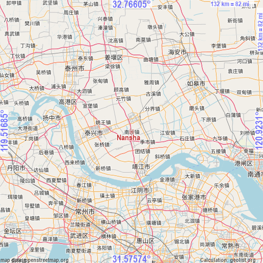
Nansha GPS coordinates[2]
32° 10' 22.224" North, 120° 13' 11.892" East
| Map corner | latitude | longitude |
|---|---|---|
| Upper-left | 32.76605°, | 119.51685° |
| Center: | 32.17284°, | 120.21997° |
| Lower-right: | 31.57574°, | 120.9231° |
| Map W x H: | 132.4×132.3 km | = 82.3×82.2mi |
| max Lat: | 53.31946° ⇑37.7% North |
| Nansha: | 32.17284° |
| min Lat: | ⇓62.3% South 18.22056° |
| min Long | Nansha | max Long |
| 75.07348° | 120.21997° | 134.28917° |
| W 83.3%⇐ | ⇒16.7% E |
Elevation
Elevation of Nansha is 8 m = 26 ft, and this is 476.8 m = 1564 ft below average elevation for this country.
| Max E: |
5622 m = 18445 ft | 92.7% |
| Avg. | 484.8 m = 1591 ft | |
| Nansha | 8 m = 26 ft | |
Min E: |
-3 m = -10 ft | 7.3% |
See also: China elevation on elevation.city.
Geographical zone
Nansha is located in North temperate zone (between Tropic of Cancer and the Arctic Circle). Distance of this Northern Tropic circle is 971.4 km =603.6 mi to South.| Distance of | km | miles | from Nansha |
|---|---|---|---|
| North Pole | 6429.8 | 3995.3 | to North |
| Arctic Circle | 3823.9 | 2376.1 | to North |
| Tropic Cancer | 971.4 | 603.6 | to South |
| Equator | 3577.3 | 2222.8 | to South |


Nearby cities:
15 places around Nansha: (largest is in red/bold)
• Changdai
15.2 km =9.4 mi,  181°
181°
• Fenjie
15.6 km =9.7 mi,  41°
41°
• Guangling
7.8 km =4.8 mi,  168°
168°
• Gushan
14 km =8.7 mi,  147°
147°
• Heshi
8.7 km =5.4 mi,  295°
295°
• Hongguang
16.3 km =10.1 mi,  221°
221°
• Huangqiao
7.6 km =4.7 mi,  9°
9°
• Jishi
9.1 km =5.7 mi,  117°
117°
• Liuchen
12.3 km =7.6 mi,  327°
327°
• Quxia
10 km =6.2 mi, 216°
• Shanhu
9.3 km =5.8 mi,  85°
85°
• Shengci
16.1 km =10 mi,  199°
199°
• Xiqiao
6.9 km =4.3 mi, 328°
• Yaowang
15.2 km =9.4 mi,  288°
288°
• Zhangqiao
16.4 km =10.2 mi,  247°
247°
Sources, notices
• [Note1] Compared only with cities in China existing in our database
• [Src1] Map data: © OpenStreetMap contributors (CC-BY-SA)
• [Src2] Other city data from geonames.org with taken over terms of usage.
• [Src3] Geographical zone / Annual Mean Temperature by Robert A. Rohde @ Wikipedia
