Zengtian geodata
Zengtian (Jiangxi) is a seat of a fourth-order administrative division; located in China in Asia/Shanghai (GMT+8) time zone. In our database, there are 1268 cities with bigger population. Compared to other cities in China, 77.2% of cities are located further ↑North; 59.1% of cities are located further ←West and 53.5% of cities have higher elevation than Zengtian. Note1


Zengtian GPS coordinates[2]
27° 21' 22.68" North, 115° 50' 20.292" East
| Map corner | latitude | longitude |
|---|---|---|
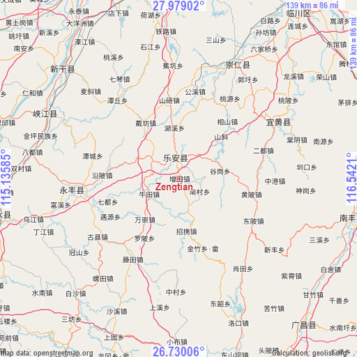
| Upper-left | 27.97902°, | 115.13585° |
| Center: | 27.3563°, | 115.83897° |
| Lower-right: | 26.73006°, | 116.5421° |
| Map W x H: | 138.9×138.9 km | = 86.3×86.3mi |
| max Lat: | 53.31946° ⇑77.2% North |
| Zengtian: | 27.3563° |
| min Lat: | ⇓22.8% South 18.22056° |
| min Long | Zengtian | max Long |
| 75.07348° | 115.83897° | 134.28917° |
| W 59.1%⇐ | ⇒40.9% E |
Elevation
Elevation of Zengtian is 140 m = 459 ft, and this is 344.8 m = 1131 ft below average elevation for this country.
| Max E: |
5622 m = 18445 ft | 53.5% |
| Avg. | 484.8 m = 1591 ft | |
| Zengtian | 140 m = 459 ft | |
Min E: |
-3 m = -10 ft | 46.5% |
See also: China elevation on elevation.city.
Geographical zone
Zengtian is located in North temperate zone (between Tropic of Cancer and the Arctic Circle). Distance of this Northern Tropic circle is 435.8 km =270.8 mi to South.| Distance of | km | miles | from Zengtian |
|---|---|---|---|
| North Pole | 6965.3 | 4328 | to North |
| Arctic Circle | 4359.4 | 2708.8 | to North |
| Tropic Cancer | 435.8 | 270.8 | to South |
| Equator | 3041.7 | 1890 | to South |


Nearby cities:
15 places around Zengtian: (largest is in red/bold)
• Aoxi
7.7 km =4.8 mi,  358°
358°
• Daifang
25.4 km =15.8 mi,  328°
328°
• Gongfang
27.6 km =17.1 mi,  342°
342°
• Gugang
16.3 km =10.1 mi,  79°
79°
• Huping
20.3 km =12.6 mi,  206°
206°
• Lugang
22.4 km =13.9 mi,  283°
283°
• Luobei
26.5 km =16.5 mi, 210°
• Nancun
9.5 km =5.9 mi,  122°
122°
• Niutian
13 km =8.1 mi,  241°
241°
• Pengzhou
18.9 km =11.7 mi,  323°
323°
• Pingxi
28.3 km =17.6 mi,  161°
161°
• Tangang
10.8 km =6.7 mi,  308°
308°
• Wanchong
20.9 km =13 mi,  220°
220°
• Wangxian
11.5 km =7.1 mi, 163°
• Zhaoxie
21.2 km =13.2 mi,  171°
171°
Sources, notices
• [Note1] Compared only with cities in China existing in our database
• [Src1] Map data: © OpenStreetMap contributors (CC-BY-SA)
• [Src2] Other city data from geonames.org with taken over terms of usage.
• [Src3] Geographical zone / Annual Mean Temperature by Robert A. Rohde @ Wikipedia
