Wangxian geodata
Wangxian (Jiangxi) is a seat of a fourth-order administrative division; located in China in Asia/Shanghai (GMT+8) time zone. In our database, there are 1268 cities with bigger population. Compared to other cities in China, 77.5% of cities are located further ↑North; 59.3% of cities are located further ←West and 51.2% of cities have higher elevation than Wangxian. Note1


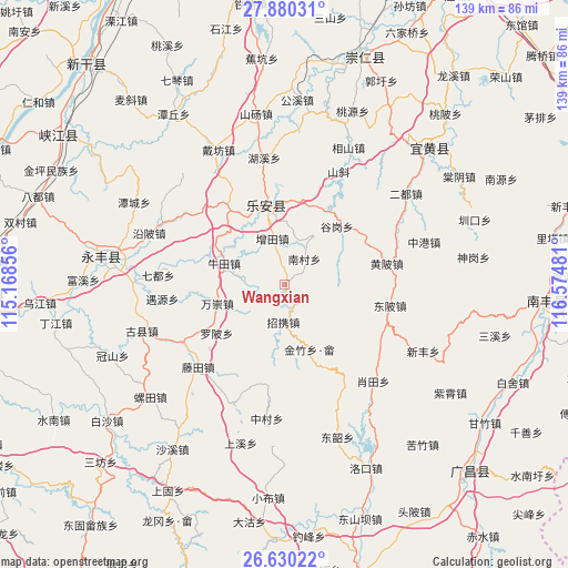
Wangxian GPS coordinates[2]
27° 15' 25.272" North, 115° 52' 18.048" East
| Map corner | latitude | longitude |
|---|---|---|
| Upper-left | 27.88031°, | 115.16856° |
| Center: | 27.25702°, | 115.87168° |
| Lower-right: | 26.63022°, | 116.57481° |
| Map W x H: | 139×139 km | = 86.4×86.4mi |
| max Lat: | 53.31946° ⇑77.5% North |
| Wangxian: | 27.25702° |
| min Lat: | ⇓22.5% South 18.22056° |
| min Long | Wangxian | max Long |
| 75.07348° | 115.87168° | 134.28917° |
| W 59.3%⇐ | ⇒40.7% E |
Elevation
Elevation of Wangxian is 155 m = 509 ft, and this is 329.8 m = 1082 ft below average elevation for this country.
| Max E: |
5622 m = 18445 ft | 51.2% |
| Avg. | 484.8 m = 1591 ft | |
| Wangxian | 155 m = 509 ft | |
Min E: |
-3 m = -10 ft | 48.8% |
See also: China elevation on elevation.city.
Geographical zone
Wangxian is located in North temperate zone (between Tropic of Cancer and the Arctic Circle). Distance of this Northern Tropic circle is 424.8 km =264 mi to South.| Distance of | km | miles | from Wangxian |
|---|---|---|---|
| North Pole | 6976.4 | 4334.9 | to North |
| Arctic Circle | 4370.5 | 2715.7 | to North |
| Tropic Cancer | 424.8 | 264 | to South |
| Equator | 3030.7 | 1883.2 | to South |


Nearby cities:
15 places around Wangxian: (largest is in red/bold)
• Aoxi
19.1 km =11.9 mi,  349°
349°
• Dongbei
26.2 km =16.3 mi,  101°
101°
• Gugang
19.1 km =11.9 mi,  42°
42°
• Huangbei
25.4 km =15.8 mi,  78°
78°
• Huping
14.2 km =8.8 mi,  239°
239°
• Jinzhu
26.2 km =16.3 mi,  175°
175°
• Luobei
20.4 km =12.7 mi,  234°
234°
• Nancun
7.6 km =4.7 mi, 39°
• Niutian
15.5 km =9.6 mi,  288°
288°
• Pingxi
16.8 km =10.4 mi,  159°
159°
• Tangang
21.3 km =13.2 mi,  326°
326°
• Taotang
27.6 km =17.1 mi,  220°
220°
• Wanchong
17.5 km =10.9 mi,  253°
253°
• Zengtian
11.5 km =7.1 mi,  343°
343°
• Zhaoxie
9.9 km =6.2 mi, 180°
Sources, notices
• [Note1] Compared only with cities in China existing in our database
• [Src1] Map data: © OpenStreetMap contributors (CC-BY-SA)
• [Src2] Other city data from geonames.org with taken over terms of usage.
• [Src3] Geographical zone / Annual Mean Temperature by Robert A. Rohde @ Wikipedia
