Niutian geodata
Niutian (Jiangxi) is a seat of a fourth-order administrative division; located in China in Asia/Shanghai (GMT+8) time zone. In our database, there are 1268 cities with bigger population. Compared to other cities in China, 77.4% of cities are located further ↑North; 58.3% of cities are located further ←West and 59.7% of cities have higher elevation than Niutian. Note1


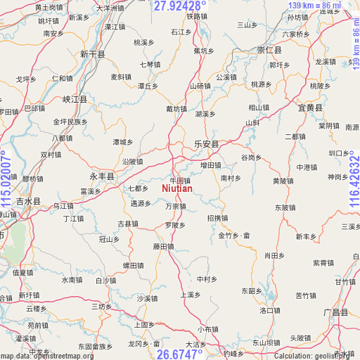
Niutian GPS coordinates[2]
27° 18' 4.5" North, 115° 43' 23.484" East
| Map corner | latitude | longitude |
|---|---|---|
| Upper-left | 27.92428°, | 115.02007° |
| Center: | 27.30125°, | 115.72319° |
| Lower-right: | 26.6747°, | 116.42632° |
| Map W x H: | 138.9×138.9 km | = 86.3×86.3mi |
| max Lat: | 53.31946° ⇑77.4% North |
| Niutian: | 27.30125° |
| min Lat: | ⇓22.6% South 18.22056° |
| min Long | Niutian | max Long |
| 75.07348° | 115.72319° | 134.28917° |
| W 58.3%⇐ | ⇒41.7% E |
Elevation
Elevation of Niutian is 100 m = 328 ft, and this is 384.8 m = 1262 ft below average elevation for this country.
| Max E: |
5622 m = 18445 ft | 59.7% |
| Avg. | 484.8 m = 1591 ft | |
| Niutian | 100 m = 328 ft | |
Min E: |
-3 m = -10 ft | 40.3% |
See also: China elevation on elevation.city.
Geographical zone
Niutian is located in North temperate zone (between Tropic of Cancer and the Arctic Circle). Distance of this Northern Tropic circle is 429.7 km =267 mi to South.| Distance of | km | miles | from Niutian |
|---|---|---|---|
| North Pole | 6971.4 | 4331.8 | to North |
| Arctic Circle | 4365.6 | 2712.7 | to North |
| Tropic Cancer | 429.7 | 267 | to South |
| Equator | 3035.6 | 1886.2 | to South |


Nearby cities:
15 places around Niutian: (largest is in red/bold)
• Aoxi
17.8 km =11.1 mi,  38°
38°
• Huping
12.3 km =7.6 mi,  168°
168°
• Lugang
15.5 km =9.6 mi,  318°
318°
• Luobei
16.9 km =10.5 mi,  186°
186°
• Nancun
19.5 km =12.1 mi,  87°
87°
• Pengzhou
21.2 km =13.2 mi,  0°
0°
• Qidu
16.7 km =10.4 mi,  260°
260°
• Tangang
13.2 km =8.2 mi,  12°
12°
• Tengtian
25.6 km =15.9 mi, 194°
• Wanchong
10.1 km =6.3 mi, 192°
• Wangxian
15.5 km =9.6 mi,  108°
108°
• Yanbei
20.3 km =12.6 mi,  291°
291°
• Yaotian
21.6 km =13.4 mi,  207°
207°
• Zengtian
13 km =8.1 mi,  61°
61°
• Zhaoxie
20.8 km =12.9 mi,  135°
135°
Sources, notices
• [Note1] Compared only with cities in China existing in our database
• [Src1] Map data: © OpenStreetMap contributors (CC-BY-SA)
• [Src2] Other city data from geonames.org with taken over terms of usage.
• [Src3] Geographical zone / Annual Mean Temperature by Robert A. Rohde @ Wikipedia
