Zengtian geodata
Zengtian (Guangdong) is a seat of a fourth-order administrative division; located in China in Asia/Shanghai (GMT+8) time zone. In our database, there are 1268 cities with bigger population. Compared to other cities in China, 90.4% of cities are located further ↑North; 54.2% of cities are located further ←West and 57.2% of cities have lower elevation than Zengtian. Note1


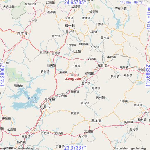
Zengtian GPS coordinates[2]
24° 1' 1.956" North, 114° 58' 59.484" East
| Map corner | latitude | longitude |
|---|---|---|
| Upper-left | 24.65785°, | 114.28007° |
| Center: | 24.01721°, | 114.98319° |
| Lower-right: | 23.37337°, | 115.68632° |
| Map W x H: | 142.8×142.8 km | = 88.7×88.7mi |
| max Lat: | 53.31946° ⇑90.4% North |
| Zengtian: | 24.01721° |
| min Lat: | ⇓9.6% South 18.22056° |
| min Long | Zengtian | max Long |
| 75.07348° | 114.98319° | 134.28917° |
| W 54.2%⇐ | ⇒45.8% E |
Elevation
Elevation of Zengtian is 227 m = 745 ft, and this is 257.8 m = 846 ft below average elevation for this country.
| Max E: |
5622 m = 18445 ft | 42.8% |
| Avg. | 484.8 m = 1591 ft | |
| Zengtian | 227 m = 745 ft | |
Min E: |
-3 m = -10 ft | 57.2% |
See also: China elevation on elevation.city.
Geographical zone
Zengtian is located in North temperate zone (between Tropic of Cancer and the Arctic Circle). Distance of this Northern Tropic circle is 64.5 km =40.1 mi to South.| Distance of | km | miles | from Zengtian |
|---|---|---|---|
| North Pole | 7336.6 | 4558.8 | to North |
| Arctic Circle | 4730.7 | 2939.5 | to North |
| Tropic Cancer | 64.5 | 40.1 | to South |
| Equator | 2670.5 | 1659.4 | to South |


Nearby cities:
15 places around Zengtian: (largest is in red/bold)
• Chuantang
16.4 km =10.2 mi,  344°
344°
• Dengta
19.9 km =12.4 mi,  267°
267°
• Huangsha
22.2 km =13.8 mi,  320°
320°
• Huangtian
15.7 km =9.8 mi,  178°
178°
• Lakou
12.3 km =7.6 mi,  127°
127°
• Lankou
12.8 km =8 mi, 125°
• Lishi
22.9 km =14.2 mi,  3°
3°
• Liucheng
13.9 km =8.6 mi,  81°
81°
• Luohu
11.6 km =7.2 mi,  286°
286°
• Shangguan
9.1 km =5.7 mi, 2°
• Tuocheng
21.4 km =13.3 mi, 76°
• Yetan
23.3 km =14.5 mi,  121°
121°
• Yidu
22.1 km =13.7 mi,  45°
45°
• Yihe
22.6 km =14 mi,  209°
209°
• Zhangxi
11.3 km =7 mi,  327°
327°
Sources, notices
• [Note1] Compared only with cities in China existing in our database
• [Src1] Map data: © OpenStreetMap contributors (CC-BY-SA)
• [Src2] Other city data from geonames.org with taken over terms of usage.
• [Src3] Geographical zone / Annual Mean Temperature by Robert A. Rohde @ Wikipedia
