Lankou geodata
Lankou (Guangdong) is a seat of a fourth-order administrative division; located in China in Asia/Shanghai (GMT+8) time zone. In our database, there are 1268 cities with bigger population. Compared to other cities in China, 90.6% of cities are located further ↑North; 54.8% of cities are located further ←West and 70% of cities have higher elevation than Lankou. Note1


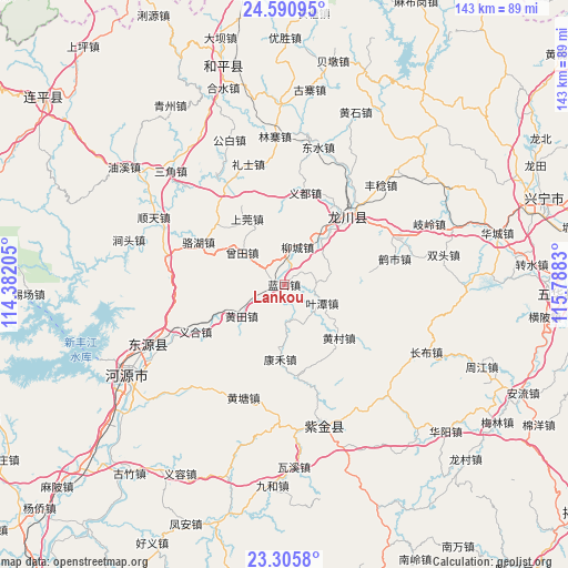
Lankou GPS coordinates[2]
23° 56' 59.928" North, 115° 5' 6.612" East
| Map corner | latitude | longitude |
|---|---|---|
| Upper-left | 24.59095°, | 114.38205° |
| Center: | 23.94998°, | 115.08517° |
| Lower-right: | 23.3058°, | 115.7883° |
| Map W x H: | 142.9×142.9 km | = 88.8×88.8mi |
| max Lat: | 53.31946° ⇑90.6% North |
| Lankou: | 23.94998° |
| min Lat: | ⇓9.4% South 18.22056° |
| min Long | Lankou | max Long |
| 75.07348° | 115.08517° | 134.28917° |
| W 54.8%⇐ | ⇒45.2% E |
Elevation
Elevation of Lankou is 52 m = 171 ft, and this is 432.8 m = 1420 ft below average elevation for this country.
| Max E: |
5622 m = 18445 ft | 70% |
| Avg. | 484.8 m = 1591 ft | |
| Lankou | 52 m = 171 ft | |
Min E: |
-3 m = -10 ft | 30% |
See also: China elevation on elevation.city.
Geographical zone
Lankou is located in North temperate zone (between Tropic of Cancer and the Arctic Circle). Distance of this Northern Tropic circle is 57.1 km =35.5 mi to South.| Distance of | km | miles | from Lankou |
|---|---|---|---|
| North Pole | 7344.1 | 4563.4 | to North |
| Arctic Circle | 4738.2 | 2944.2 | to North |
| Tropic Cancer | 57.1 | 35.5 | to South |
| Equator | 2663 | 1654.7 | to South |


Nearby cities:
15 places around Lankou: (largest is in red/bold)
• Fucheng
22.4 km =13.9 mi,  41°
41°
• Huangbu
22.1 km =13.7 mi,  81°
81°
• Huangcun
19.2 km =11.9 mi,  131°
131°
• Huangtian
12.9 km =8 mi,  230°
230°
• Jiushe
22.9 km =14.2 mi,  214°
214°
• Kanghe
19 km =11.8 mi,  180°
180°
• Lakou
0.5 km =0.3 mi,  275°
275°
• Laolong
23.8 km =14.8 mi, 44°
• Liucheng
10 km =6.2 mi,  19°
19°
• Shangguan
19.4 km =12.1 mi,  328°
328°
• Tuocheng
16.3 km =10.1 mi, 40°
• Yetan
10.6 km =6.6 mi,  116°
116°
• Yidu
23.7 km =14.7 mi,  12°
12°
• Zengtian
12.8 km =8 mi,  305°
305°
• Zhangxi
23.7 km =14.7 mi,  315°
315°
Sources, notices
• [Note1] Compared only with cities in China existing in our database
• [Src1] Map data: © OpenStreetMap contributors (CC-BY-SA)
• [Src2] Other city data from geonames.org with taken over terms of usage.
• [Src3] Geographical zone / Annual Mean Temperature by Robert A. Rohde @ Wikipedia
