Liucheng geodata
Liucheng (Guangdong) is a seat of a fourth-order administrative division; located in China in Asia/Shanghai (GMT+8) time zone. In our database, there are 1268 cities with bigger population. Compared to other cities in China, 90.3% of cities are located further ↑North; 55% of cities are located further ←West and 62.3% of cities have higher elevation than Liucheng. Note1


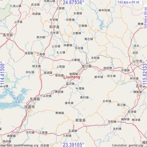
Liucheng GPS coordinates[2]
24° 2' 5.316" North, 115° 7' 5.52" East
| Map corner | latitude | longitude |
|---|---|---|
| Upper-left | 24.67536°, | 114.41508° |
| Center: | 24.03481°, | 115.1182° |
| Lower-right: | 23.39105°, | 115.82133° |
| Map W x H: | 142.8×142.8 km | = 88.7×88.7mi |
| max Lat: | 53.31946° ⇑90.3% North |
| Liucheng: | 24.03481° |
| min Lat: | ⇓9.7% South 18.22056° |
| min Long | Liucheng | max Long |
| 75.07348° | 115.1182° | 134.28917° |
| W 55%⇐ | ⇒45% E |
Elevation
Elevation of Liucheng is 86 m = 282 ft, and this is 398.8 m = 1308 ft below average elevation for this country.
| Max E: |
5622 m = 18445 ft | 62.3% |
| Avg. | 484.8 m = 1591 ft | |
| Liucheng | 86 m = 282 ft | |
Min E: |
-3 m = -10 ft | 37.7% |
See also: China elevation on elevation.city.
Geographical zone
Liucheng is located in North temperate zone (between Tropic of Cancer and the Arctic Circle). Distance of this Northern Tropic circle is 66.5 km =41.3 mi to South.| Distance of | km | miles | from Liucheng |
|---|---|---|---|
| North Pole | 7334.6 | 4557.5 | to North |
| Arctic Circle | 4728.8 | 2938.3 | to North |
| Tropic Cancer | 66.5 | 41.3 | to South |
| Equator | 2672.4 | 1660.6 | to South |


Nearby cities:
15 places around Liucheng: (largest is in red/bold)
• Chuantang
22.8 km =14.2 mi,  307°
307°
• Fucheng
13.6 km =8.5 mi,  57°
57°
• Huangbu
19.4 km =12.1 mi,  108°
108°
• Huangtian
22.1 km =13.7 mi,  217°
217°
• Lakou
10.1 km =6.3 mi,  202°
202°
• Lankou
10 km =6.2 mi, 199°
• Laolong
15.3 km =9.5 mi, 60°
• Lishi
24.3 km =15.1 mi,  329°
329°
• Shangguan
15.2 km =9.4 mi,  298°
298°
• Sidu
24.2 km =15 mi,  33°
33°
• Tuocheng
7.8 km =4.8 mi,  67°
67°
• Yetan
15.4 km =9.6 mi,  156°
156°
• Yidu
13.8 km =8.6 mi,  8°
8°
• Zengtian
13.9 km =8.6 mi,  261°
261°
• Zhangxi
21.3 km =13.2 mi,  290°
290°
Sources, notices
• [Note1] Compared only with cities in China existing in our database
• [Src1] Map data: © OpenStreetMap contributors (CC-BY-SA)
• [Src2] Other city data from geonames.org with taken over terms of usage.
• [Src3] Geographical zone / Annual Mean Temperature by Robert A. Rohde @ Wikipedia
