Zaoxi geodata
Zaoxi (Zhejiang) is a seat of a fourth-order administrative division; located in China in Asia/Shanghai (GMT+8) time zone. In our database, there are 1268 cities with bigger population. Compared to other cities in China, 52% of cities are located further ↑North; 78.7% of cities are located further ←West and 55.7% of cities have higher elevation than Zaoxi. Note1


Zaoxi GPS coordinates[2]
30° 12' 2.16" North, 119° 29' 24.36" East
| Map corner | latitude | longitude |
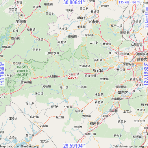
|---|---|---|
| Upper-left | 30.80641°, | 118.78698° |
| Center: | 30.2006°, | 119.4901° |
| Lower-right: | 29.59104°, | 120.19323° |
| Map W x H: | 135.1×135.1 km | = 83.9×83.9mi |
| max Lat: | 53.31946° ⇑52% North |
| Zaoxi: | 30.2006° |
| min Lat: | ⇓48% South 18.22056° |
| min Long | Zaoxi | max Long |
| 75.07348° | 119.4901° | 134.28917° |
| W 78.7%⇐ | ⇒21.3% E |
Elevation
Elevation of Zaoxi is 126 m = 413 ft, and this is 358.8 m = 1177 ft below average elevation for this country.
| Max E: |
5622 m = 18445 ft | 55.7% |
| Avg. | 484.8 m = 1591 ft | |
| Zaoxi | 126 m = 413 ft | |
Min E: |
-3 m = -10 ft | 44.3% |
See also: China elevation on elevation.city.
Geographical zone
Zaoxi is located in North temperate zone (between Tropic of Cancer and the Arctic Circle). Distance of this Northern Tropic circle is 752.1 km =467.3 mi to South.| Distance of | km | miles | from Zaoxi |
|---|---|---|---|
| North Pole | 6649.1 | 4131.6 | to North |
| Arctic Circle | 4043.2 | 2512.3 | to North |
| Tropic Cancer | 752.1 | 467.3 | to South |
| Equator | 3358 | 2086.6 | to South |


Nearby cities:
15 places around Zaoxi: (largest is in red/bold)
• Changhua
26.4 km =16.4 mi,  262°
262°
• Dongqiao
16.5 km =10.3 mi,  147°
147°
• Gaohong
25.9 km =16.1 mi,  59°
59°
• Henglu
20.8 km =12.9 mi,  305°
305°
• Leping
23 km =14.3 mi,  202°
202°
• Linglong
14.2 km =8.8 mi,  94°
94°
• Lin’an
22.3 km =13.9 mi,  79°
79°
• Qianchuan
15.5 km =9.6 mi,  218°
218°
• Qianhong
11.2 km =7 mi, 306°
• Shanggan
21.5 km =13.4 mi,  98°
98°
• Taiyang
18.7 km =11.6 mi, 264°
• Wanshi
13.7 km =8.5 mi, 146°
• Xitianmu
7.4 km =4.6 mi,  346°
346°
• Yinzhu
25.3 km =15.7 mi, 196°
• Yuqian
9.4 km =5.8 mi, 261°
Sources, notices
• [Note1] Compared only with cities in China existing in our database
• [Src1] Map data: © OpenStreetMap contributors (CC-BY-SA)
• [Src2] Other city data from geonames.org with taken over terms of usage.
• [Src3] Geographical zone / Annual Mean Temperature by Robert A. Rohde @ Wikipedia
