Yuqian geodata
Yuqian (Zhejiang) is a seat of a fourth-order administrative division; located in China in Asia/Shanghai (GMT+8) time zone. In our database, there are 1268 cities with bigger population. Compared to other cities in China, 52.2% of cities are located further ↑North; 78.2% of cities are located further ←West and 59.7% of cities have higher elevation than Yuqian. Note1


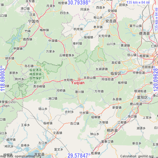
Yuqian GPS coordinates[2]
30° 11' 17.16" North, 119° 23' 35.34" East
| Map corner | latitude | longitude |
|---|---|---|
| Upper-left | 30.79398°, | 118.69003° |
| Center: | 30.1881°, | 119.39315° |
| Lower-right: | 29.57847°, | 120.09628° |
| Map W x H: | 135.2×135.2 km | = 84×84mi |
| max Lat: | 53.31946° ⇑52.2% North |
| Yuqian: | 30.1881° |
| min Lat: | ⇓47.8% South 18.22056° |
| min Long | Yuqian | max Long |
| 75.07348° | 119.39315° | 134.28917° |
| W 78.2%⇐ | ⇒21.8% E |
Elevation
Elevation of Yuqian is 100 m = 328 ft, and this is 384.8 m = 1262 ft below average elevation for this country.
| Max E: |
5622 m = 18445 ft | 59.7% |
| Avg. | 484.8 m = 1591 ft | |
| Yuqian | 100 m = 328 ft | |
Min E: |
-3 m = -10 ft | 40.3% |
See also: China elevation on elevation.city.
Geographical zone
Yuqian is located in North temperate zone (between Tropic of Cancer and the Arctic Circle). Distance of this Northern Tropic circle is 750.7 km =466.5 mi to South.| Distance of | km | miles | from Yuqian |
|---|---|---|---|
| North Pole | 6650.5 | 4132.4 | to North |
| Arctic Circle | 4044.6 | 2513.2 | to North |
| Tropic Cancer | 750.7 | 466.5 | to South |
| Equator | 3356.6 | 2085.7 | to South |


Nearby cities:
15 places around Yuqian: (largest is in red/bold)
• Changhua
17 km =10.6 mi,  262°
262°
• Dongqiao
22.1 km =13.7 mi,  124°
124°
• Henglu
15.5 km =9.6 mi,  330°
330°
• Heqiao
18.3 km =11.4 mi,  239°
239°
• Leping
19.8 km =12.3 mi,  178°
178°
• Linglong
23.5 km =14.6 mi,  89°
89°
• Qianchuan
10.8 km =6.7 mi, 181°
• Qianhong
8.1 km =5 mi,  2°
2°
• Taiyang
9.3 km =5.8 mi,  268°
268°
• Wanshi
19.7 km =12.2 mi, 120°
• Xitianmu
11.5 km =7.1 mi,  41°
41°
• Yihe
25.6 km =15.9 mi,  188°
188°
• Yinzhu
23 km =14.3 mi,  174°
174°
• Yunti
23.3 km =14.5 mi, 332°
• Zaoxi
9.4 km =5.8 mi,  81°
81°
Sources, notices
• [Note1] Compared only with cities in China existing in our database
• [Src1] Map data: © OpenStreetMap contributors (CC-BY-SA)
• [Src2] Other city data from geonames.org with taken over terms of usage.
• [Src3] Geographical zone / Annual Mean Temperature by Robert A. Rohde @ Wikipedia
