Yuyao geodata
Yuyao (Zhejiang) is a seat of a third-order administrative division; located in China in Asia/Shanghai (GMT+8) time zone. With population of 114,177 people, there are 380 cities with bigger population in this country. Compared to other cities in China, 53.5% of cities are located further ↑North; 88.4% of cities are located further ←West and 68.2% of cities have higher elevation than Yuyao. Note1


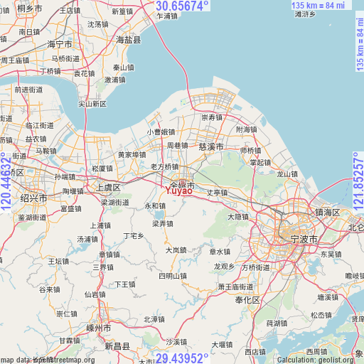
Yuyao GPS coordinates[2]
30° 3' 0" North, 121° 8' 57.984" East
| Map corner | latitude | longitude |
|---|---|---|
| Upper-left | 30.65674°, | 120.44632° |
| Center: | 30.05°, | 121.14944° |
| Lower-right: | 29.43952°, | 121.85257° |
| Map W x H: | 135.3×135.3 km | = 84.1×84.1mi |
| max Lat: | 53.31946° ⇑53.5% North |
| Yuyao: | 30.05° |
| min Lat: | ⇓46.5% South 18.22056° |
| min Long | Yuyao | max Long |
| 75.07348° | 121.14944° | 134.28917° |
| W 88.4%⇐ | ⇒11.6% E |
Elevation
Elevation of Yuyao is 59 m = 194 ft, and this is 425.8 m = 1397 ft below average elevation for this country.
| Max E: |
5622 m = 18445 ft | 68.2% |
| Avg. | 484.8 m = 1591 ft | |
| Yuyao | 59 m = 194 ft | |
Min E: |
-3 m = -10 ft | 31.8% |
See also: Yuyao elevation on elevation.city.
Geographical zone
Yuyao is located in North temperate zone (between Tropic of Cancer and the Arctic Circle). Distance of this Northern Tropic circle is 735.3 km =456.9 mi to South.| Distance of | km | miles | from Yuyao |
|---|---|---|---|
| North Pole | 6665.8 | 4141.9 | to North |
| Arctic Circle | 4059.9 | 2522.7 | to North |
| Tropic Cancer | 735.3 | 456.9 | to South |
| Equator | 3341.2 | 2076.1 | to South |


Nearby cities:
15 places around Yuyao: (largest is in red/bold)
• Hemudu
17.1 km =10.6 mi,  114°
114°
• Henghe
12.2 km =7.6 mi,  43°
43°
• Langxia
14.9 km =9.3 mi,  331°
331°
• Liangnong
16.9 km =10.5 mi,  205°
205°
• Lubu
10.2 km =6.3 mi,  130°
130°
• Mazhu
10.3 km =6.4 mi,  287°
287°
• Moushan
15.6 km =9.7 mi,  280°
280°
• Simen
16.3 km =10.1 mi,  319°
319°
• Tianyuan
16.9 km =10.5 mi,  10°
10°
• Xiaodong
5.1 km =3.2 mi,  248°
248°
• Xushan
16.8 km =10.4 mi,  33°
33°
• Yongheshi
13.2 km =8.2 mi,  229°
229°
• Zhangting
13.5 km =8.4 mi, 106°
• Zhouxiang
14 km =8.7 mi,  351°
351°
• Zonghan
17.4 km =10.8 mi,  24°
24°
Sources, notices
• [Note1] Compared only with cities in China existing in our database
• [Src1] Map data: © OpenStreetMap contributors (CC-BY-SA)
• [Src2] Other city data from geonames.org with taken over terms of usage.
• [Src3] Geographical zone / Annual Mean Temperature by Robert A. Rohde @ Wikipedia
