Liangnong geodata
Liangnong (Zhejiang) is a seat of a fourth-order administrative division; located in China in Asia/Shanghai (GMT+8) time zone. In our database, there are 1268 cities with bigger population. Compared to other cities in China, 54.9% of cities are located further ↑North; 88.1% of cities are located further ←West and 77.7% of cities have higher elevation than Liangnong. Note1


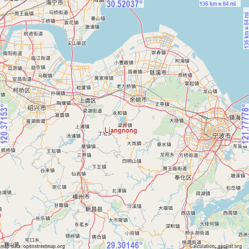
Liangnong GPS coordinates[2]
29° 54' 46.008" North, 121° 4' 28.74" East
| Map corner | latitude | longitude |
|---|---|---|
| Upper-left | 30.52037°, | 120.37153° |
| Center: | 29.91278°, | 121.07465° |
| Lower-right: | 29.30146°, | 121.77778° |
| Map W x H: | 135.5×135.5 km | = 84.2×84.2mi |
| max Lat: | 53.31946° ⇑54.9% North |
| Liangnong: | 29.91278° |
| min Lat: | ⇓45.1% South 18.22056° |
| min Long | Liangnong | max Long |
| 75.07348° | 121.07465° | 134.28917° |
| W 88.1%⇐ | ⇒11.9% E |
Elevation
Elevation of Liangnong is 31 m = 102 ft, and this is 453.8 m = 1489 ft below average elevation for this country.
| Max E: |
5622 m = 18445 ft | 77.7% |
| Avg. | 484.8 m = 1591 ft | |
| Liangnong | 31 m = 102 ft | |
Min E: |
-3 m = -10 ft | 22.3% |
See also: China elevation on elevation.city.
Geographical zone
Liangnong is located in North temperate zone (between Tropic of Cancer and the Arctic Circle). Distance of this Northern Tropic circle is 720.1 km =447.4 mi to South.| Distance of | km | miles | from Liangnong |
|---|---|---|---|
| North Pole | 6681.1 | 4151.4 | to North |
| Arctic Circle | 4075.2 | 2532.2 | to North |
| Tropic Cancer | 720.1 | 447.4 | to South |
| Equator | 3326 | 2066.7 | to South |


Nearby cities:
15 places around Liangnong: (largest is in red/bold)
• Chenxikou
10.8 km =6.7 mi,  191°
191°
• Fenghui
10.3 km =6.4 mi,  293°
293°
• Haoba
22.4 km =13.9 mi,  282°
282°
• Lianghu
19.1 km =11.9 mi,  297°
297°
• Lubu
17.3 km =10.7 mi,  60°
60°
• Mazhu
18.6 km =11.6 mi,  351°
351°
• Moushan
19.8 km =12.3 mi,  335°
335°
• Ruanzhuang
15.4 km =9.6 mi,  196°
196°
• Shangyu
22.7 km =14.1 mi, 300°
• Simingshan
20 km =12.4 mi,  170°
170°
• Xiaguan
8.8 km =5.5 mi,  209°
209°
• Xiaodong
13.6 km =8.5 mi,  10°
10°
• Xiaoyue
22.6 km =14 mi,  321°
321°
• Yongheshi
7.2 km =4.5 mi, 337°
• Yuyao
16.9 km =10.5 mi,  25°
25°
Sources, notices
• [Note1] Compared only with cities in China existing in our database
• [Src1] Map data: © OpenStreetMap contributors (CC-BY-SA)
• [Src2] Other city data from geonames.org with taken over terms of usage.
• [Src3] Geographical zone / Annual Mean Temperature by Robert A. Rohde @ Wikipedia
