Yutian geodata
Yutian (Hebei) is a seat of a third-order administrative division; located in China in Asia/Shanghai (GMT+8) time zone. In our database, there are 1268 cities with bigger population. Compared to other cities in China, 86% of cities are located further ↓South; 69.6% of cities are located further ←West and 83.4% of cities have higher elevation than Yutian. Note1


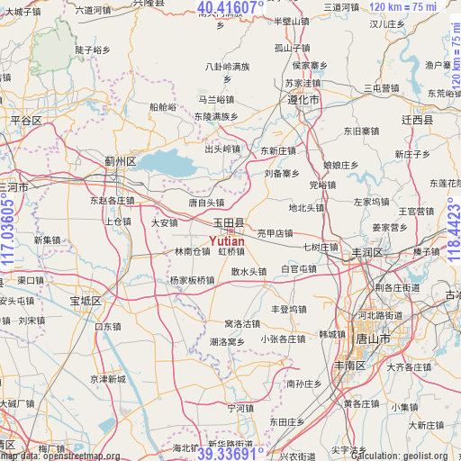
Yutian GPS coordinates[2]
39° 52' 42.996" North, 117° 44' 21.012" East
| Map corner | latitude | longitude |
|---|---|---|
| Upper-left | 40.41607°, | 117.03605° |
| Center: | 39.87861°, | 117.73917° |
| Lower-right: | 39.33691°, | 118.4423° |
| Map W x H: | 120×120 km | = 74.6×74.6mi |
| max Lat: | 53.31946° ⇑14% North |
| Yutian: | 39.87861° |
| min Lat: | ⇓86% South 18.22056° |
| min Long | Yutian | max Long |
| 75.07348° | 117.73917° | 134.28917° |
| W 69.6%⇐ | ⇒30.4% E |
Elevation
Elevation of Yutian is 19 m = 62 ft, and this is 465.8 m = 1528 ft below average elevation for this country.
| Max E: |
5622 m = 18445 ft | 83.4% |
| Avg. | 484.8 m = 1591 ft | |
| Yutian | 19 m = 62 ft | |
Min E: |
-3 m = -10 ft | 16.6% |
See also: China elevation on elevation.city.
Geographical zone
Yutian is located in North temperate zone (between Tropic of Cancer and the Arctic Circle). Distance of this Northern Tropic circle is 1828.2 km =1136 mi to South.| Distance of | km | miles | from Yutian |
|---|---|---|---|
| North Pole | 5573 | 3462.9 | to North |
| Arctic Circle | 2967.1 | 1843.7 | to North |
| Tropic Cancer | 1828.2 | 1136 | to South |
| Equator | 4434.1 | 2755.2 | to South |


Nearby cities:
15 places around Yutian: (largest is in red/bold)
• Beitan
28.4 km =17.6 mi,  241°
241°
• Dabao’anzhen
22.5 km =14 mi,  275°
275°
• Dahengshang
21.5 km =13.4 mi,  259°
259°
• Dayanggezhuang
27.7 km =17.2 mi, 256°
• Dazhongzhuang
26.6 km =16.5 mi,  214°
214°
• Dongzhaogezhuang
32.4 km =20.1 mi, 283°
• Fangjiazhuang
31.9 km =19.8 mi, 238°
• Fengrun
32.6 km =20.3 mi,  98°
98°
• Mengquan
23.2 km =14.4 mi, 255°
• Shangcang
30 km =18.6 mi,  274°
274°
• Xiacang
29.4 km =18.3 mi,  249°
249°
• Xin’anzhen
22.5 km =14 mi,  231°
231°
• Yangezhuang
13.7 km =8.5 mi,  342°
342°
• Yangjinzhuang
29.1 km =18.1 mi, 271°
• Yinliu
31.4 km =19.5 mi,  291°
291°
Sources, notices
• [Note1] Compared only with cities in China existing in our database
• [Src1] Map data: © OpenStreetMap contributors (CC-BY-SA)
• [Src2] Other city data from geonames.org with taken over terms of usage.
• [Src3] Geographical zone / Annual Mean Temperature by Robert A. Rohde @ Wikipedia
