Fengrun geodata
Fengrun (Hebei) is a populated place; located in China in Asia/Shanghai (GMT+8) time zone. With population of 65,150 people, there are 668 cities with bigger population in this country. Compared to other cities in China, 85.8% of cities are located further ↓South; 71.1% of cities are located further ←West and 79.3% of cities have higher elevation than Fengrun. Note1


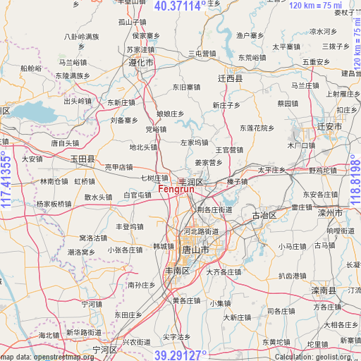
Fengrun GPS coordinates[2]
39° 49' 59.988" North, 118° 7' 0.012" East
| Map corner | latitude | longitude |
|---|---|---|
| Upper-left | 40.37114°, | 117.41355° |
| Center: | 39.83333°, | 118.11667° |
| Lower-right: | 39.29127°, | 118.8198° |
| Map W x H: | 120.1×120.1 km | = 74.6×74.6mi |
| max Lat: | 53.31946° ⇑14.2% North |
| Fengrun: | 39.83333° |
| min Lat: | ⇓85.8% South 18.22056° |
| min Long | Fengrun | max Long |
| 75.07348° | 118.11667° | 134.28917° |
| W 71.1%⇐ | ⇒28.9% E |
Elevation
Elevation of Fengrun is 28 m = 92 ft, and this is 456.8 m = 1499 ft below average elevation for this country.
| Max E: |
5622 m = 18445 ft | 79.3% |
| Avg. | 484.8 m = 1591 ft | |
| Fengrun | 28 m = 92 ft | |
Min E: |
-3 m = -10 ft | 20.7% |
See also: Fengrun elevation on elevation.city.
Geographical zone
Fengrun is located in North temperate zone (between Tropic of Cancer and the Arctic Circle). Distance of this Northern Tropic circle is 1823.1 km =1132.8 mi to South.| Distance of | km | miles | from Fengrun |
|---|---|---|---|
| North Pole | 5578 | 3466 | to North |
| Arctic Circle | 2972.1 | 1846.8 | to North |
| Tropic Cancer | 1823.1 | 1132.8 | to South |
| Equator | 4429.1 | 2752.1 | to South |


Nearby cities:
15 places around Fengrun: (largest is in red/bold)
• Dazhongzhuang
50.2 km =31.2 mi,  250°
250°
• Fengtai
43.9 km =27.3 mi,  225°
225°
• Guye
30 km =18.6 mi,  112°
112°
• Jiangwakou
49.5 km =30.8 mi, 225°
• Kaiping
20.8 km =12.9 mi,  146°
146°
• Linxi
31.5 km =19.6 mi,  115°
115°
• Nanmaizhu
48.6 km =30.2 mi,  220°
220°
• Penguanzhuang
46.7 km =29 mi,  213°
213°
• Tangjiazhuang
30.3 km =18.8 mi, 109°
• Tangshan
23 km =14.3 mi,  165°
165°
• Xin’anzhen
50.7 km =31.5 mi,  259°
259°
• Yangezhuang
40.6 km =25.2 mi,  296°
296°
• Yutian
32.6 km =20.3 mi,  278°
278°
• Zhaogezhuang
26.3 km =16.3 mi, 106°
• Zunhua
40.7 km =25.3 mi,  340°
340°
Sources, notices
• [Note1] Compared only with cities in China existing in our database
• [Src1] Map data: © OpenStreetMap contributors (CC-BY-SA)
• [Src2] Other city data from geonames.org with taken over terms of usage.
• [Src3] Geographical zone / Annual Mean Temperature by Robert A. Rohde @ Wikipedia
