Zhaojiagang geodata
Zhaojiagang (Hunan) is a seat of a fourth-order administrative division; located in China in Asia/Shanghai (GMT+8) time zone. In our database, there are 1268 cities with bigger population. Compared to other cities in China, 59.8% of cities are located further ↑North; 68.4% of cities are located further →East and 50.2% of cities have lower elevation than Zhaojiagang. Note1


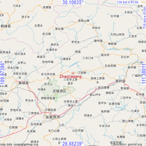
Zhaojiagang GPS coordinates[2]
29° 29' 46.392" North, 110° 40' 37.128" East
| Map corner | latitude | longitude |
|---|---|---|
| Upper-left | 30.10635°, | 109.97386° |
| Center: | 29.49622°, | 110.67698° |
| Lower-right: | 28.88239°, | 111.38011° |
| Map W x H: | 136.1×136.1 km | = 84.6×84.6mi |
| max Lat: | 53.31946° ⇑59.8% North |
| Zhaojiagang: | 29.49622° |
| min Lat: | ⇓40.2% South 18.22056° |
| min Long | Zhaojiagang | max Long |
| 75.07348° | 110.67698° | 134.28917° |
| W 31.6%⇐ | ⇒68.4% E |
Elevation
Elevation of Zhaojiagang is 167 m = 548 ft, and this is 317.8 m = 1043 ft below average elevation for this country.
| Max E: |
5622 m = 18445 ft | 49.8% |
| Avg. | 484.8 m = 1591 ft | |
| Zhaojiagang | 167 m = 548 ft | |
Min E: |
-3 m = -10 ft | 50.2% |
See also: China elevation on elevation.city.
Geographical zone
Zhaojiagang is located in North temperate zone (between Tropic of Cancer and the Arctic Circle). Distance of this Northern Tropic circle is 673.8 km =418.7 mi to South.| Distance of | km | miles | from Zhaojiagang |
|---|---|---|---|
| North Pole | 6727.4 | 4180.2 | to North |
| Arctic Circle | 4121.5 | 2561 | to North |
| Tropic Cancer | 673.8 | 418.7 | to South |
| Equator | 3279.7 | 2037.9 | to South |


Nearby cities:
15 places around Zhaojiagang: (largest is in red/bold)
• Baishi
24.7 km =15.3 mi,  338°
338°
• Gaofeng
24.2 km =15 mi,  105°
105°
• Huochiyu
20.2 km =12.6 mi,  259°
259°
• Jiangya
8.5 km =5.3 mi,  83°
83°
• Renchaoxi
15.3 km =9.5 mi,  324°
324°
• Sanguansi
7.7 km =4.8 mi,  198°
198°
• Sanhekou
20.3 km =12.6 mi,  44°
44°
• Shanmuqiao
25.1 km =15.6 mi, 79°
• Wulingyuan
20.8 km =12.9 mi,  218°
218°
• Xianchiyu
20.2 km =12.6 mi, 259°
• Xiangshi
15.7 km =9.8 mi, 81°
• Xilian
20.9 km =13 mi,  13°
13°
• Yujiazui
19.4 km =12.1 mi,  214°
214°
• Zhuyeping
13.3 km =8.3 mi, 258°
• Zoumaping
23 km =14.3 mi, 263°
Sources, notices
• [Note1] Compared only with cities in China existing in our database
• [Src1] Map data: © OpenStreetMap contributors (CC-BY-SA)
• [Src2] Other city data from geonames.org with taken over terms of usage.
• [Src3] Geographical zone / Annual Mean Temperature by Robert A. Rohde @ Wikipedia
