Yuexi geodata
Yuexi (Chongqing) is a seat of a fourth-order administrative division; located in China in Asia/Shanghai (GMT+8) time zone. In our database, there are 1268 cities with bigger population. Compared to other cities in China, 54% of cities are located further ↓South; 80% of cities are located further →East and 56.3% of cities have lower elevation than Yuexi. Note1


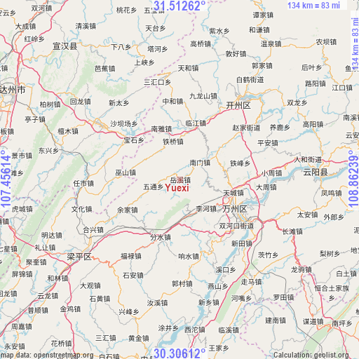
Yuexi GPS coordinates[2]
30° 54' 40.572" North, 108° 9' 33.336" East
| Map corner | latitude | longitude |
|---|---|---|
| Upper-left | 31.51262°, | 107.45614° |
| Center: | 30.91127°, | 108.15926° |
| Lower-right: | 30.30612°, | 108.86239° |
| Map W x H: | 134.2×134.2 km | = 83.4×83.4mi |
| max Lat: | 53.31946° ⇑46% North |
| Yuexi: | 30.91127° |
| min Lat: | ⇓54% South 18.22056° |
| min Long | Yuexi | max Long |
| 75.07348° | 108.15926° | 134.28917° |
| W 20%⇐ | ⇒80% E |
Elevation
Elevation of Yuexi is 219 m = 719 ft, and this is 265.8 m = 872 ft below average elevation for this country.
| Max E: |
5622 m = 18445 ft | 43.7% |
| Avg. | 484.8 m = 1591 ft | |
| Yuexi | 219 m = 719 ft | |
Min E: |
-3 m = -10 ft | 56.3% |
See also: China elevation on elevation.city.
Geographical zone
Yuexi is located in North temperate zone (between Tropic of Cancer and the Arctic Circle). Distance of this Northern Tropic circle is 831.1 km =516.4 mi to South.| Distance of | km | miles | from Yuexi |
|---|---|---|---|
| North Pole | 6570.1 | 4082.5 | to North |
| Arctic Circle | 3964.2 | 2463.2 | to North |
| Tropic Cancer | 831.1 | 516.4 | to South |
| Equator | 3437 | 2135.7 | to South |


Nearby cities:
15 places around Yuexi: (largest is in red/bold)
• Changsha
17 km =10.6 mi,  54°
54°
• Danzi
15.8 km =9.8 mi,  247°
247°
• Fenshui
22.5 km =14 mi,  198°
198°
• Gaoliang
16.7 km =10.4 mi,  125°
125°
• Houshan
15.7 km =9.8 mi,  232°
232°
• Lihe
14.4 km =8.9 mi,  137°
137°
• Linjiang
21.7 km =13.5 mi,  15°
15°
• Nanmen
9.8 km =6.1 mi, 54°
• Nanya
20.5 km =12.7 mi,  340°
340°
• Taibai
21.2 km =13.2 mi,  116°
116°
• Tiancheng
20.7 km =12.9 mi,  103°
103°
• Tieqiao
14.5 km =9 mi,  350°
350°
• Wushan
20.5 km =12.7 mi,  278°
278°
• Wutong
10.1 km =6.3 mi,  256°
256°
• Zhoujiaba
21.2 km =13.2 mi,  110°
110°
Sources, notices
• [Note1] Compared only with cities in China existing in our database
• [Src1] Map data: © OpenStreetMap contributors (CC-BY-SA)
• [Src2] Other city data from geonames.org with taken over terms of usage.
• [Src3] Geographical zone / Annual Mean Temperature by Robert A. Rohde @ Wikipedia
