Houshan geodata
Houshan (Chongqing) is a seat of a fourth-order administrative division; located in China in Asia/Shanghai (GMT+8) time zone. In our database, there are 1268 cities with bigger population. Compared to other cities in China, 53.2% of cities are located further ↓South; 80.5% of cities are located further →East and 78.1% of cities have lower elevation than Houshan. Note1


Houshan GPS coordinates[2]
30° 49' 33.204" North, 108° 1' 43.176" East
| Map corner | latitude | longitude |
|---|---|---|
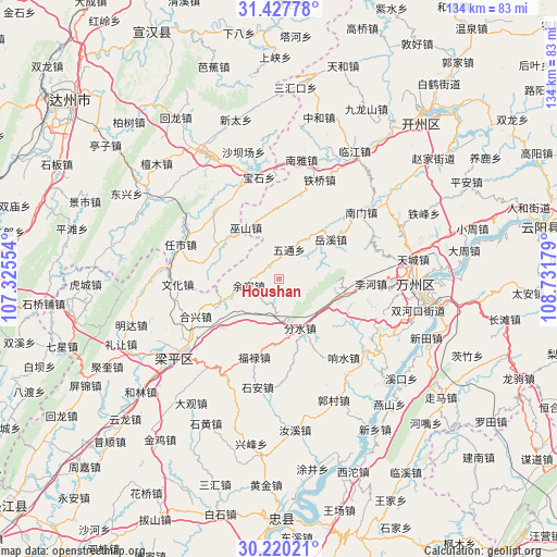
| Upper-left | 31.42778°, | 107.32554° |
| Center: | 30.82589°, | 108.02866° |
| Lower-right: | 30.22021°, | 108.73179° |
| Map W x H: | 134.3×134.3 km | = 83.5×83.5mi |
| max Lat: | 53.31946° ⇑46.8% North |
| Houshan: | 30.82589° |
| min Lat: | ⇓53.2% South 18.22056° |
| min Long | Houshan | max Long |
| 75.07348° | 108.02866° | 134.28917° |
| W 19.5%⇐ | ⇒80.5% E |
Elevation
Elevation of Houshan is 620 m = 2034 ft, and this is 135.2 m = 444 ft above average elevation for this country.
| Max E: |
5622 m = 18445 ft | 21.9% |
| Houshan | 620 m 2034 ft | |
| Avg. | 484.8 m = 1591 ft | |
Min E: |
-3 m = -10 ft | 78.1% |
See also: China elevation on elevation.city.
Geographical zone
Houshan is located in North temperate zone (between Tropic of Cancer and the Arctic Circle). Distance of this Northern Tropic circle is 821.6 km =510.5 mi to South.| Distance of | km | miles | from Houshan |
|---|---|---|---|
| North Pole | 6579.5 | 4088.3 | to North |
| Arctic Circle | 3973.7 | 2469.1 | to North |
| Tropic Cancer | 821.6 | 510.5 | to South |
| Equator | 3427.5 | 2129.7 | to South |


Nearby cities:
15 places around Houshan: (largest is in red/bold)
• Chengdong
17.6 km =10.9 mi,  228°
228°
• Danzi
4.1 km =2.5 mi,  327°
327°
• Fenshui
12.9 km =8 mi,  156°
156°
• Fulu
19.9 km =12.4 mi,  196°
196°
• Hexing
21.9 km =13.6 mi,  245°
245°
• Lihe
22.3 km =13.9 mi,  92°
92°
• Qushui
15.9 km =9.9 mi,  182°
182°
• Sunjia
10.8 km =6.7 mi,  187°
187°
• Wenhua
24.3 km =15.1 mi,  266°
266°
• Wushan
14.7 km =9.1 mi, 327°
• Wutong
7.6 km =4.7 mi,  20°
20°
• Xiangshui
24.7 km =15.3 mi,  140°
140°
• Xiaping
15.4 km =9.6 mi, 247°
• Yuexi
15.7 km =9.8 mi,  52°
52°
• Yujia
7.3 km =4.5 mi,  257°
257°
Sources, notices
• [Note1] Compared only with cities in China existing in our database
• [Src1] Map data: © OpenStreetMap contributors (CC-BY-SA)
• [Src2] Other city data from geonames.org with taken over terms of usage.
• [Src3] Geographical zone / Annual Mean Temperature by Robert A. Rohde @ Wikipedia
