Chongqing geodata
Chongqing is a seat of a first-order administrative division; located in China in Asia/Shanghai (GMT+8) time zone. With population of 7,457,600 people, there are 7 cities with bigger population in this country. Compared to other cities in China, 59% of cities are located further ↑North; 85% of cities are located further →East and 56.9% of cities have lower elevation than Chongqing. Note1


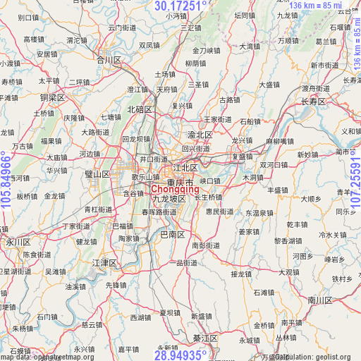
Chongqing GPS coordinates[2]
29° 33' 46.008" North, 106° 33' 10.008" East
| Map corner | latitude | longitude |
|---|---|---|
| Upper-left | 30.17251°, | 105.84966° |
| Center: | 29.56278°, | 106.55278° |
| Lower-right: | 28.94935°, | 107.25591° |
| Map W x H: | 136×136 km | = 84.5×84.5mi |
| max Lat: | 53.31946° ⇑59% North |
| Chongqing: | 29.56278° |
| min Lat: | ⇓41% South 18.22056° |
| min Long | Chongqing | max Long |
| 75.07348° | 106.55278° | 134.28917° |
| W 15%⇐ | ⇒85% E |
Elevation
Elevation of Chongqing is 225 m = 738 ft, and this is 259.8 m = 852 ft below average elevation for this country.
| Max E: |
5622 m = 18445 ft | 43.1% |
| Avg. | 484.8 m = 1591 ft | |
| Chongqing | 225 m = 738 ft | |
Min E: |
-3 m = -10 ft | 56.9% |
See also: Chongqing elevation on elevation.city.
Geographical zone
Chongqing is located in North temperate zone (between Tropic of Cancer and the Arctic Circle). Distance of this Northern Tropic circle is 681.2 km =423.3 mi to South.| Distance of | km | miles | from Chongqing |
|---|---|---|---|
| North Pole | 6720 | 4175.6 | to North |
| Arctic Circle | 4114.1 | 2556.4 | to North |
| Tropic Cancer | 681.2 | 423.3 | to South |
| Equator | 3287.1 | 2042.5 | to South |


Nearby cities:
15 places around Chongqing: (largest is in red/bold)
• Changshengqiao
12 km =7.5 mi,  119°
119°
• Cuntan
4.7 km =2.9 mi,  21°
21°
• Dazhulin
11.3 km =7 mi,  309°
309°
• Geleshan
13.7 km =8.5 mi,  277°
277°
• Huixing
14.8 km =9.2 mi, 23°
• Jiguanshi
6.1 km =3.8 mi,  54°
54°
• Lijia
14.1 km =8.8 mi,  335°
335°
• Nanping
4.2 km =2.6 mi,  125°
125°
• Renhe
7.4 km =4.6 mi, 339°
• Tongjiaxi
17.2 km =10.7 mi,  322°
322°
• Xinshancun
11.2 km =7 mi,  220°
220°
• Yangjiaping
8.1 km =5 mi, 217°
• Yinglong
16.4 km =10.2 mi,  106°
106°
• Yuanyang
11.5 km =7.1 mi,  2°
2°
• Yufengshan
15.7 km =9.8 mi,  44°
44°
Sources, notices
• [Note1] Compared only with cities in China existing in our database
• [Src1] Map data: © OpenStreetMap contributors (CC-BY-SA)
• [Src2] Other city data from geonames.org with taken over terms of usage.
• [Src3] Geographical zone / Annual Mean Temperature by Robert A. Rohde @ Wikipedia
